inscribed and signed with initials "Ahrweiler / LWT"
Tom and Laura Taylor and thence by descent
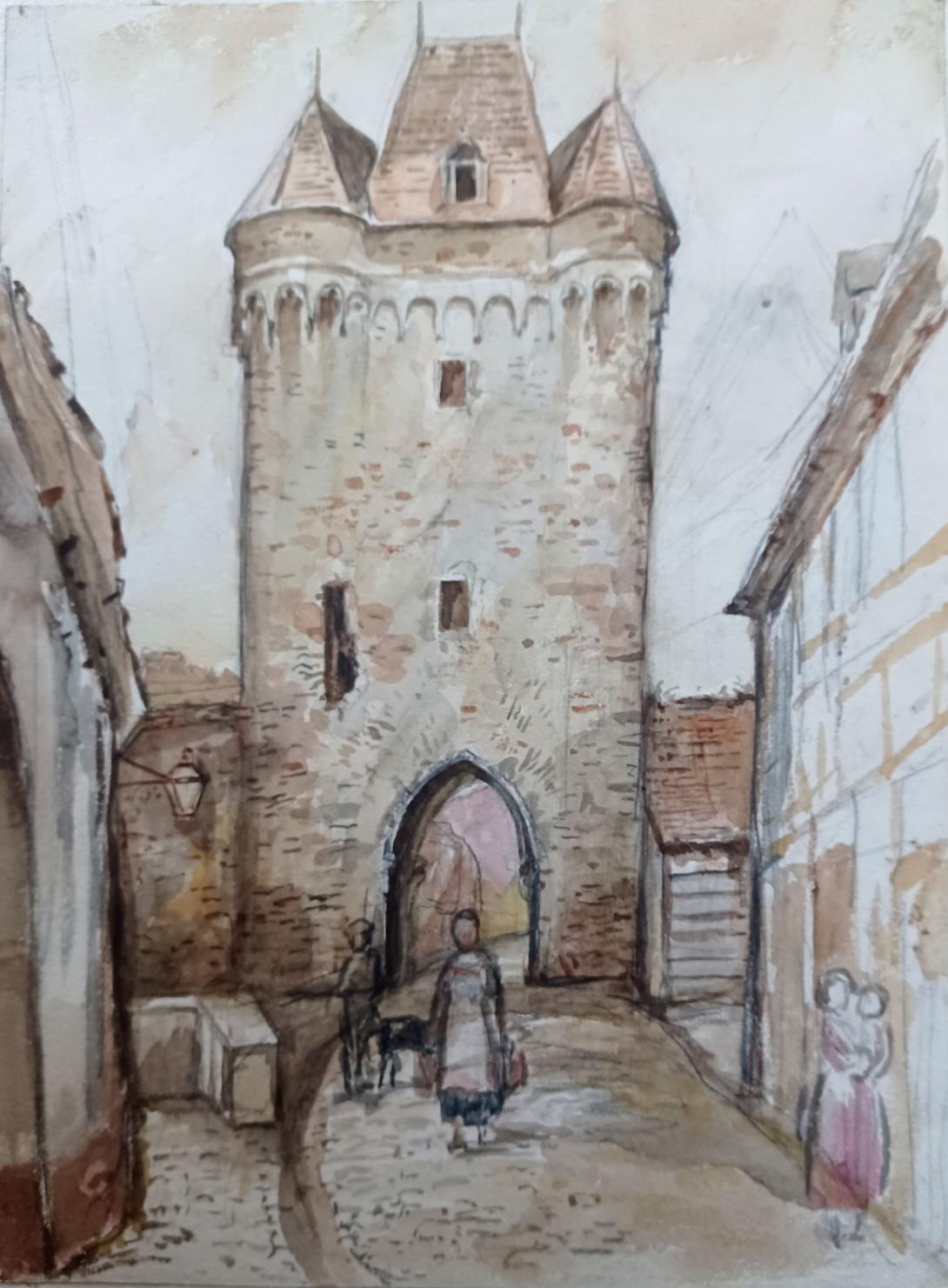
The 20.50 meter high Obertor is - along with the Nieder, Ahr and Adenbachtor - one of the four city gates first documented in writing in 1297 and part of the city wall and thus the city fortifications of Ahrweiler. It is also called “Walporzheimer Tor” after the neighboring town of Walporzheim, and “Gesemer Porz” or “Westtor” after the former Gisenhoven desert. The three-story tower gate with a cantilevered upper floor, four corner turrets and a hipped roof is located in the west of the city and is dedicated to Saint Ursula, who is also the pastor of the upper guard.
On the second floor of the pointed arch gate there is a toilet bay window on the right side of the ditch. There is also a display case with a sculpture of St. Ursula, the patron saint of Ahrweiler and the gate. On the inside of the gate there is a St. Ursula relief made of basalt, which is framed with a garland of fir branches decorated with white rose petals every year on the patron saint's name day on October 21st.
As a remnant of the siege of Ahrweiler by troops of Cologne Archbishop Ruprecht von der Pfalz in 1474, historical stone cannonballs are now walled into the wall on the west side of the gate, towards Walporzheim. Three of them can be seen directly above the pointed arch of the passage, and if you look further up, you can see four more directly under the cantilevered upper floor, making a total of seven balls. On a (incorrect) bronze information board on the south side it says about the upper gate:
Western gate tower of the city fortifications from the 13th-15th centuries. Century, four-story with a cantilevered upper floor, four corner towers and a pointed hipped roof. Outside: pointed arch gate, portcullis slot, pitch nose, three walled-in stone balls to commemorate the siege by the Burgundian troops of Charles the Bold in 1476, figure of St. Ursula with protective cloak, patroness of the Oberhut.
Not visible from above, the Bad Neuenahr-Ahrweiler mill pond passes under the city fortifications in the area of the upper gate and flows into the city center. To prevent attackers from entering the city through the moat, this area was protected with iron bars. In times of crisis and war, the city moat, which consisted of four segments, was flooded with water at this point.
Architectural historical studies came to the conclusion that the

Upper Gate was built between 1254 and 1267. Until the siege of

Ahrweiler by troops of Cologne Archbishop Ruprecht von der Pfalz

 in 1474, the Obertor was a three-walled gate, i.e. open to the city,

as the Bitzenturm, which is not far away, is still today. It was only

 around 1500 that an inner wall was built into the upper gate; The

seams can still be clearly seen with the naked eye today. On the

outside of the gate there is a pointed arch gate with a portcullis slot

and a pitch nose.
After several on-site visits, the General Directorate of Cultural Heritage, the highest monument protection authority in Rhineland-Palatinate, gave the green light for the renovation of the upper gate in spring 2019. At that time, the structure had cracks up to eight centimeters wide, which were mainly visible from the inside on the southeast wall and in the vault above the passage and which threatened the stability of the historic tower. The built-in parts of the facade such as consoles and blind arches as well as the roof covering were also in poor condition, as Mayor Guido Orthen told the main committee of the city of Bad Neuenahr-Ahrweiler on April 15, 2019. The renovation, which was estimated at 386,000 euros, was subject to strict conditions. The city expected state funding of up to 75 percent. As part of the renovation, the facade is to be statically secured with an anchor system. Missing stones should be replaced to match the existing structure, and loose or incorrect joint mortar should be replaced with joint renovation mortar. The roofing, wooden formwork and slate covering are to be replaced and the cornices are to be renovated. Construction was scheduled to begin in spring 2020.
In fact, the scaffolding of the gate only began in October 2020. During the course of the renovation, the cracks would be removed, “which simply arose over time and not as a result of subsidence caused by the mill pond that flows right next door,” reported construction technician Sybille Laubner from the building and property management department of the Bad Neuenahr-Ahrweiler city administration. The Rhein-Zeitung (RZ) reported this on October 31, 2020, shortly after the renovation began. Particularly on the south side of the gate, where the cold-heat tension due to the sun is greatest, cracks up to 18 millimeters wide have developed that run through the entire height of the structure. The seams, which are still clearly visible today and were created by the installation of the wall facing the city center, are also problem areas, as are the two pedestrian passages that were broken on the right and left of the gate in 1905 and 1935. Unlike the Ahr and Niedertor, the Obertor lacks stone ceilings that could provide additional stability. Up to 80 percent of the approximately 386,000 euros estimated for the renovation would be covered by funds from the General Directorate of Cultural Heritage of Rhineland-Palatinate and the urban renovation, the RZ also reported. The renovation should be divided into three phases:
In addition to its stone outer walls, the tower only has a wooden interior over three floors, which can be reached via ladders. The only access to the gate is through the apartment and over the terrace of a historic private residential building on the north side of the gate, the Peter-Friedhofen-Haus.
1.During the first renovation phase, which is not visible from the outside, the gate will be structurally strengthened. To do this, a specialist company from Ilmtal on Weinstrasse 16 drills ten centimeters in diameter into the masonry. 16 anchors are to be pressed into it with the purpose of restoring the stability of the structure. “The masonry is not pulled together to close the cracks, but rather the current state should be maintained and strengthened,” reported Jochen Tarrach in the RZ.
2. The second renovation phase should begin in spring 2021, which includes the renovation of the roof and roof substructure. All other wooden areas would also be assessed and, if necessary, small areas would be renovated.
3. As part of the third renovation phase, which is scheduled to be completed in summer 2021, the joints in the quarry stone masonry will be renovated and crumbled stones will be replaced. Because the historic quarry no longer exists, quarry stones from the Mayen/Mendig area are used.
Bad Neuenahr-Ahrweiler is a spa town in the German Bundesland of Rhineland-Palatinate that serves as the capital of the Ahrweiler district. The A61 motorway connects the town with cities like Cologne and Mainz. Formed by the merging of the towns (now districts) of Bad Neuenahr and Ahrweiler in 1969, Bad Neuenahr-Ahrweiler consists of 11 such districts.
Bad Neuenahr-Ahrweiler rests in the Ahr valley (German: Ahrtal) on the left bank of the Rhine river in the north of Rhineland-Palatinate. Bad Neuenahr-Ahrweiler nestles in the Ahr Hills (German: Ahrgebirge).
The highest hill in the area is the Häuschen at 506 metres (1,660 ft) metres above sea level. Nearby are the hills of Steckenberg, Neuenahrer, and Talerweiterung. There used to be castles on the last two of these hills.
Bad Neuenahr-Ahrweiler is surrounded by the following villages and towns (clockwise from the north): Grafschaft, Remagen, Sinzig, Königsfeld, Schalkenbach, Heckenbach, Kesseling, Rech and Dernau. The nearest cities are Bonn and Koblenz.
Bad Neuenahr is divided into Ortsbezirke which consist of one or more districts. The Ortsbezirke are represented by local councils. The largest district, Bad Neuenahr, was originally made up of three communities, which are still seen as districts.
Population statistics as of 31 March 2013 (main and secondary residence):
Discoveries dating to the Hallstatt period (1000–500 BC) show farming activity by Celts that dwelled in the area. The Gallic Wars (58–50 BC) resulted in the forced relocation of the indigenous Eburones to the Middle Rhine. Several Roman discoveries date from the 1st to 3rd centuries. Most notable is the Villa Rustica of Bad Neuenahr [de].
In 893 AD, Ahrweiler was mentioned as Arwilre, Arewilre, Arewilere, and later Areweiller in the Prüm Urbar (register of estates owned by Prüm Abbey). The abbey of Ahrweiler owned a manor with 24 farmsteads; 50 acres of farmland and 76 acres of vineyards. The first mention of a parish church occurred in Neuenahr Castle and surrounding county (Newenare) from 1204 to 1225. In 1246 was founded one of the oldest German inns Gasthaus Sanct Peter.
Close to Bad Neuenahr-Ahrweiler, the national Government bunker was built between 1960 and 1972 inside two abandoned railway tunnels that were built as part of the Strategic Railway. The bunker was maintained and kept in a working condition for about 30 years and decommissioned in 1997. The location is a museum since February 2008.
During the 2021 European floods much of the town was submerged and many died.
- The German Army's (German: Deutsches Heer) Logistics Centre (main depot) is located in an underground facility.
- Bad Neuenahr-Ahrweiler has been home to the traditional mineral water "Heppinger" since 1584.
- The "Apollinaris" mineral water company was founded in Bad Neuenahr in 1852.
Ahrweiler (German: [ˈaːɐ̯ˌvaɪlɐ]) is a district in the north of Rhineland-Palatinate, Germany. It is bounded by (from the north and clockwise) the districts of Euskirchen, Rhein-Sieg and the city of Bonn in the state of North Rhine-Westphalia, and the districts of Neuwied, Mayen-Koblenz and Vulkaneifel.
The region was conquered by the Romans under Julius Caesar about 50 BC. Some hundred years later the Roman fort of Rigomagus (Gaulish for "king's field") was founded, later to become the city of Remagen. The Vinxtbach, a narrow brook and an affluent of the Rhine, was defined as the borderline between the Roman provinces of Germania superior and Germania inferior. There was originally a Roman villa here; the German suffix, "weiler", is from the Latin term "villare", meaning "land attached to a Roman villa, farm". Portions of a Roman aqueduct have also been found nearby.
Many towns were first mentioned in the 9th century, among them Sinzig and the eponymous village of Ahrweiler (since 1969 a part of Bad Neuenahr-Ahrweiler). The name of Ahrweiler was first noted in the Land Register of the Abbey of Prüm, which during the ninth century, owned almost all of the property in the town.
In 1180, the Holy Roman Emperor Barbarossa chose Sinzig as a place to meet the envoys of France and Flanders. Another significant place was the Abbey of Maria Laach on the Laacher See, a lake in the southeast of the district.
From 1100 to 1246, the district was ruled by the Grafen (Counts) von Are (Ahr), and then by their relatives, the Grafen von Hochstaden. These families were mainly responsible for the development of Ahrweiler, which then was, together with Bonn, Andernach and Nürburg, one of the capitals of the Archbishopric of Cologne. Defensive walls, ramparts and towers were built around the town, and these constructions remain mostly unimpaired. In the early years of the Holy Roman Empire there was a county of Ahr, but it was annexed by the Bishop of Cologne in 1246. Afterwards Remagen became the most important town of the region. The parish church, St. Laurentius (St. Laurence) de:St. Laurentius (Ahrweiler), was originally built in 1269.
Since the Middle Ages, the town has been roughly divided by the four City Gates. In each division there was a commons, which originally belonged to the town's citizens. These were later put in the care of the protective Social Communities, who protected the interests of the inhabitants.These Social Communities (Hutengemeinschaften) continue to exist. They are: Hutengemeinschaft Adenbachhut Ahrweiler; Hutengemeinschaft "St. Barbara" Ahrhut Ahrweiler; Hutengemeinschaft "St. Katharina" Niederhut Ahrweiler; Hutengemeinschaft "St. Ursula" Oberhut Ahrweiler e.V..
During a disastrous period in the Thirty Years War in the 17th century, the town was besieged, plundered and set on fire by the French. But the darkest day in Ahrweiler's history was on May 1, 1689, when the town was razed to the ground, and only ten houses were left standing among the ruins.
The districts of Ahrweiler and Adenau were established in 1816, just after Prussia occupied the Rhineland. The district of Adenau was merged with Ahrweiler in 1932.
The Ahrweiler City Gate and many other historical buildings were partially destroyed at the end of World War II during the contested advances of the Allies. The battle of the Rhine bridge of Remagen, otherwise known as the Ludendorff Bridge, in 1945, is a well-known event in local history, also due to the U.S. movie The Bridge at Remagen (1969).
In Jewish texts, the town was called Aroil'ra (ארוילרא). From the 13th century and on, there was a considerable Jewish community in Ahrweiler. In the 14th century, the Jews of the town traded in salt and wine. During that period, the Jewish community of the town suffered from the Black Death Jewish persecutions. In 1900, 65 Jews lived in the town (1% of the total population), and 319 in 1933.

Although much of the town resisted early National Socialism, and the town leaders had refused Adolf Hitler a chance to address the community in 1932, they were not able to escape the reach of the Nazis entirely. Ahrweiler had a small Jewish community before the Nazis came to power, but they were all taken away and relocated, some to concentration camps, after 1933. No member of this community ever returned to Ahrweiler, and today, the town's old synagogue that was desecrated during 1938 Kristallnacht, is used for art displays.
The Rhine forms the eastern border of the district. The Ahr, a tributary of the Rhine, enters the district in the southeast and runs northeastwards to meet the Rhine within the borders of the district.
Ahrweiler is located in the northernmost part of the Eifel mountains. The mountains to the north of the Ahr are called the Ahr Hills; they are lower than the mountains of the High Eifel in the south of the district.
Walporzheim, one kilometre west of Ahrweiler, has some curious rock formations called the "Bunte Kuh" (Colorful Cow) and the "Kaiserstuhl" (Emperor's Chair).
The forests of the Eifel are the result of reforestations in the 19th century. The most common tree is the fir, which was originally not native to the region. The Ahr river and its smaller affluents serve as a habitat for rare animals, that are adapted to alluvial forests. Examples are the oriole, the nightingale and the endangered black kite. Some fens in the area were drained in the 20th century. The Rodder Maar, a lake in the eastern part of the district, was drained in the 1950s, and a coniferous forest was planted on the former water body; in 1998 the lake was restored, and rare animals begin to arrive there again. The geology of the lake is uncertain. In its circular shape it appears similar to volcanic maars that are found in the nearby Daum region, but there is no evidence of volcanism, and so it is not a "maar".In 2013 evidence that it is meteoritic in origin was presented.
.jpg)
.jpg)
Ahrweiler is also characterised by orchards and vineyards. The lower Ahr River is one of the northernmost wine regions of Germany, known for its red wines from Pinot noir (Spätburgunder) and Portugieser.
Ahrweiler is especially well known for its vineyards and wineries. Wine growing and trading has been going on in Ahrweiler for over 1,000 years. The town is the chief cultivator for the red wine known as "Ahrburgunder". Bachem, which lies one kilometre south of Ahrweiler, is also well known for its "Frühburgunder", a local name for Pinot Noir Précoce. Traditionally, in this small town more of this wine is produced than in any other place in the Ahr valley.
On the first Sunday in September there is a traditional and annual wine festival in Ahrweiler, for which a "Wine Queen," or "Burgundia", is elected. Within the district are also the wine festival on the first Sunday in July at Bachem and another one in nearby Walporzheim on the first Sunday in August. By the way, Walporzheim also has the oldest wine house in the Ahr, named St. Peters, which dates from 1246.
The Nürburgring, a famous Formula One circuit, is located in the district.
The coat of arms was adopted in 1927. It displays:
- Top left: the cross of Cologne
- Top right: the heraldic eagle of the earldom of Ahr
- Bottom left: the lion of Berg
- Bottom right: the former coat of arms of the Prussian Rhine province
Laura Wilson Barker (6 March 1819 – 22 May 1905), was a composer, performer and artist, sometimes also referred to as Laura Barker, Laura W Taylor or "Mrs Tom Taylor".
She was born in Thirkleby, North Yorkshire, third daughter of a clergyman, the Rev. Thomas Barker. She studied privately with Cipriani Potter and became an accomplished pianist and violinist. As a young girl Barker performed with both Louis Spohr and Paganini. She began composing in the mid-1830s - her Seven Romances for voice and guitar were published in 1837. From around 1843 until 1855 she taught music at York School for the Blind. During this period some of her compositions - including a symphony in manuscript, on 19 April 1845 - were performed at York Choral Society concerts.
On 19 June 1855 she married the English dramatist, critic, biographer, public servant, and editor of Punch magazine Tom Taylor. Barker contributed music to at least one of her husband's plays, an overture and entr'acte to Joan of Arc (1871), and provided harmonisations as an appendix to his translation of Ballads and Songs of Brittany (1865).
Her other works include the cantata Enone (1850), the violin sonata A Country Walk (1860), theatre music for As You Like It, (April 1880), Songs of Youth (1884), string quartets, madrigals and solo songs. Her choral setting of Keats's A Prophecy, composed in 1850, was performed for the first time 49 years later at the Hovingham Festival in 1899. The composer was present.
Several of Barker's paintings hang at Smallhythe Place in Kent, Ellen Terry's house.
Barker lived with her husband and family at 84 Lavender Sweep, Battersea. There were two children: the artist John Wycliffe Taylor (1859–1925), and Laura Lucy Arnold Taylor (1863–1940). The Sunday musical soirees at the house attracted many well-known attendees, including Lewis Carroll, Charles Dickens, Henry Irving, Charles Reade, Alfred Tennyson, Ellen Terry and William Makepeace Thackeray.
Tom Taylor died suddenly at his home in 1880 at the age of 62. After his death, his widow retired to Porch House, Coleshill in Buckinghamshire, where she died on 22 May 1905, aged 86.