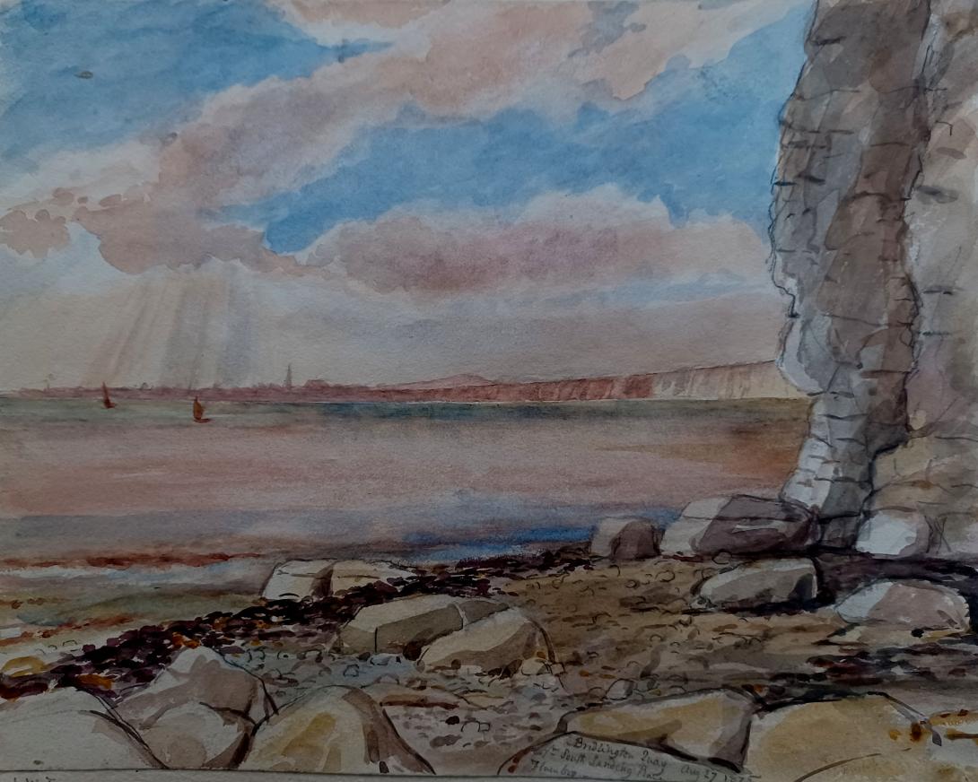
inscribed and dated "Bridlington Quay Aug 27 1875 from south Landing Place Flamborough" and signed with initials "LWT"
Tom and Laura Taylor and thence by descent
Flamborough village is thought to have been colonized over 1,100 years ago by Scandinavians, and was referred to as "Fleneburg" in the Domesday Book (1086). Before this, there was also a Roman presence, which is evidenced by Beacon Hill, once the site of a Roman signal station. The village, cut off by the enormous defensive earthwork, erroneously called Dane's Dyke, still, to this day, has a distinctive character. Fishing was first recorded in the 13th century, when about nine boats fished the seas off the Head. By the 1890s, some eighty "cobles" were registered. Now, although some fishing is still carried on, the village relies to a greater extent on tourism. However, as the old postcards on this page demonstrate, Flamborough has always been a popular destination. Site of the new Lifeboat station and perhaps not as spectacular as North Landing, but with a better beach which is wonderful for picnics. South Landing is a ten minute walk from the Manor House (North Landing is almost two miles away) and, in addition to the beach itself, there is a circular nature trail walk around the top of the cliffs and the main cliff-top walk which takes you to the Lighthouse. The photographs are all from the circular walk, which takes approximately half an hour.
Fishing has always been important here. Evidence has been uncovered revealing a medieval harbour. Today the strong influence of the sea in our lives is marked out on the bridge spanning the stream. Look for the inscriptions of cobles, small local fishing boats that worked from the harbour. Turn back and spot the names of whales, hinting back to a time when they were viewed very differently.
This Local Nature Reserve is a special place where the sheltered woods, stunning cliffs and salty seashore are all full of surprises. Located on the magnificent Flamborough Headland overlooking Bridlington Bay, South Landing beach is a beautiful expanse of sand and chalk pebbles. It is a perfect spot for a family day out where you can have a picnic then explore the rock pools or sit and watch the seabirds on the wing.
South Landing was declared a Local Nature Reserve in 2002 in recognition of its wildlife value and its importance to the local community. Local Nature Reserves aim to protect places of special interest and provide opportunities for research, education and informal enjoyment.
The reserve is part of one of the finest stretches of coastland on the east coast, and is the most northerly outcrop of coastal chalk in the British Isles. This unique sea and cliff environment is protected as a Site of Special Scientific Interest and its seabird colonies mark it as a Special Protection Area. The offshore environment has been identified as a Sensitive Marine Area and a Special Area of Conservation. In 1979 the area was designated a Heritage Coast due to its rich history and landscape.
While the cottage itself was only built in in the early 1900s, Flamborough is steeped in history. Cottages were originally built from the chalkstone in the cliffs and thatched with wheat straw from headland fields, while most of today’s older brick buildings were built in the 1800s. The roads and village centre streets are almost unchanged from centuries ago except the broken stone surfaces have been tarmacked. It is supposed to have been an important Roman station and the fishing heritage of the village can be traced all the way back to the 13th century.
Flamborough is well placed at equal distance from both North and South Landing. This originally gave fishermen opportunity to launch their cobles from either site depending on the direction of the wind on any given day. Traditional Yorkshire cobles were specially designed and built to operate in areas with no harbour. The shallow keel allows the boats to be dragged up and down the beach. It also offers stability at sea and when landing on the shore.
The design of the coble was reportedly based on the Viking longboat. They were originally powered by oars and sail but have now been modernised to include an engine and motorised pot hauler. At one time, as many as 80 coble boats operated out of the bay, but now only a few cobles operate from North Landing. The history of Flamborough certainly has much to do with the name of the cottage! Keep an eye out when walking through Flamborough for the pretty coble window boxes.
Flamborough’s lifeboat stations also form part of the headland’s living history. Lifeboats were first placed at Flamborough in 1871 and two Stations were established, one at North Landing and one at South Landing. The idea behind this was that one lifeboat could be launched whatever the conditions; if weather or sea prevented the launch of the lifeboat from North Landing, the South Landing boat would be able to get away, and vice-versa.
The two stations operated together for a period of 67 years. In 1938, the Station at South Landing was closed due to the arrival of the motorised lifeboat at North Landing in 1934. In 1993, the RNLI built a brand-new boathouse on the original site at South Landing, permanently closing the station at North Landing. The South Landing site is operational to present day with local crew from the village. From their inception to the present day, the headland’s lifeboat crews have saved hundreds of lives, adding to the rich history of Flamborough.
Flamborough Castle, also known as Danish Tower, was a medieval fortified manor house with a tower owned by the Constable family. Alongside the manor house and tower, the site once held a hall, great parlour, Lord’s parlour, a chapel, a court house, a mill house and a great barn. Now all that remains of the house, other than the surrounding earthworks, are three walls of the lower part of the tower. Precisely when it was abandoned is unknown but by 1798, the Tower was ruined. It is now owned privately by a local farmer, putting their animals out to graze on the surrounding land.
Bridlington is a seaside town and civil parish in the East Riding of Yorkshire, England. It is on the Holderness part (Flamborough Head to the Humber estuary) of the Yorkshire Coast by the North Sea. The town is about 28 miles (45 km) north of Hull and 34 miles (55 km) east of York. The stream called Gypsey Race flows through the town and enters the North Sea at the harbour.
The Priory Church of St Mary and associated Bayle (or gate) are Grade I listed buildings on the site of an Augustinian Priory. As a sea-fishing port, the town is known for shellfish, and is the largest lobster port in Europe, with over 300 tonnes of the crustaceans landed there each year. It has been termed the "Lobster Capital of Europe". Alongside manufacturing, retail and service firms, its main trade is summer tourism. It holds one of the UK's coastal weather stations.
Archaeological evidence shows habitation of the area around the Bronze Age and Romano Britain era. The date of earliest habitation at Bridlington is unknown, but the 2.5-mile (4 km) man-made Danes Dyke at nearby Flamborough Head goes back to the Bronze Age.
A Roman road from York, now Woldgate, can be traced across the Yorkshire Wolds into the town. Roman coins have been found: two hoards in the harbour area, along with two Greek coins from the second century BC — suggesting the port was in use long before the Roman conquest of Britain.
In the fourth century AD, Count Theodosius set up signal stations on the North Yorkshire coast to warn of Saxon raids. It has been suggested that the current town was built near the site of a Roman maritime station called Gabrantovicorum. In the early second-century, Ptolemy described what was possibly Bridlington Bay in his Geography as Γαβραντουικων Ευλίμενος κόλπος "Gabrantwikone bay suitable for a harbour". No sheltered ancient harbour has been found, coastal erosion will have destroyed traces of any Roman installation near the harbour.
Another station at Flamborough Head is also believed to have had one – probably on Beacon Hill (now a gravel quarry) from where Filey, Scarborough Castle and the Whitby promontory can be seen. Another suggestion has been a line of signal stations stretching south round Bridlington Bay. A fort at Bridlington would have made a centre of operations for these. This counterpart to the northern chain would have guarded a huge accessible anchorage from barbarian piracy.
Near Dukes Park are two bowl barrows known as Butt Hills, designated ancient monuments in the National Heritage List for England of Historic England. Nearby are remains of an Anglo-Saxon cemetery on a farm outside Sewerby. The several suggested origins all trace the name to the Anglo-Saxon custom of matching a personal name with a settlement type. Here the personal names advanced include Bretel, Bridla and Berhtel, attached to -ingtūn, an Old English term for a small farming community. In 1072 the area was given to Gilbert de Gant, uncle of the later king King Stephen, it was inherited by his son Walter and thereafter appears to follow the normal descent of that family.
The 1086 Domesday Book is earliest known reference to Bridlington being record as Bretlinton: the settlement has since been called Berlington, Brellington and Britlington before gaining its present name in the 19th century. The Domesday Book records that Bretlinton was the Hunthow Wapentake's meeting point (the wapentake later merged with neighbouring wapentakes to form the Dickering Wapentake). The wapentake was held by Earl Morcar, it later passed to William the Conqueror by forfeiture. It also records the effect of the Harrying of the North: the annual value of the land had fallen from £32 in the time of Edward the Confessor to eight shillings (£0.40) at the time of the survey, comprising two villeins and one socman with one and a half Carucate, the rest being waste.
Walter de Gant founded an Augustinian priory on the land in 1133, confirmed by Henry I in a charter. Several succeeding kings confirmed and extended Walter de Gant's gift: King Stephen granted an additional right to have a port, King John in 1200 gave permission for a weekly market and an annual fair, and Henry VI allowed three annual fairs, on the Nativity of Mary and the Deposition and Translation of St John of Bridlington in 1446. In 1415 Henry V visited the Priory to give thanks for victory at the Battle of Agincourt.
After the Dissolution of the Monasteries, the manor of Bridlington remained with the Crown until 1624, when Charles I passed it to Sir John Ramsey, who had recently been created Earl of Holderness. In 1633, Sir George Ramsey sold the manor to 13 inhabitants of the town, on behalf of all the manor tenants. In May 1636, a deed was drawn up empowering the 13 men as Lords Feoffees or trust holders of the Manor of Bridlington.
.jpg)
The town began to grow in importance and size around the site of the dispersed priory. In 1643 Queen Henrietta Maria of France landed there with troops to support the Royalist cause in the English Civil War, before moving on to York, which became her headquarters.
,_Yorkshire,_England-LCCN2002708301.jpg)
The town was originally two settlements: the Old Town about one mile (1.6 km) inland and the Quay area where the modern harbour lies. In 1837, an Act of Parliament enabled the wooden piers to be replaced with two stone piers to the north and south. Apart from landing fish, the port was used to transport corn: the 1826 Corn Exchange can still be seen in Market Place. There used to be mills in the town for grinding it, which led to some breweries starting up locally.
In the Second World War, Bridlington suffered several air raids that caused deaths and much bomb damage. The Royal Air Force had training schools in the town collectively known as RAF Bridlington, with one unit, No. 1104 Marine Craft Unit, continuing until 1980. Like most industry, these had petered out by the late 20th century.
Bridlington is within the unitary authority of the East Riding of Yorkshire. Its three wards are Bridlington North, Bridlington South and Bridlington Old Town and Central, returning eight councillors out of 67. The civil parish consists of the town of Bridlington and the villages of Bessingby and Sewerby. It is run by a town council of twelve councillors, of which the three wards each return four.
The Town Council coat of arms is described as:
Per Sable and Argent three Gothic Capital letters B counterchanged on a Chief embattled of the second two Barrulets wavy Azure and for the Crest Issuant from a Coronet composed of eight Roses set upon a rim of a Sun rising Gules.
with the motto:
Signum Salutis Semper
meaning Always the bringer of good health.
Bridlington lies in the large East Yorkshire parliamentary constituency that covers the mostly rural, northern part of the county, including the towns of Driffield, Market Weighton and Pocklington. Its size and shape correspond to the East Yorkshire/North Wolds District under the earlier county of Humberside.
The town has been subject to several changes in parliamentary representation. From 1290 to 1831 it was part of the large Yorkshire constituency, sending two members until 1826, when it gained an additional two. Thereafter it was part of the East Riding of Yorkshire constituency until 1885, returning two members. Further reform reduced the boundaries again, to a single-member Buckrose seat until 1950. From 1950 to 1997, Bridlington had its own MP, until reform extended the boundary to include more countryside, as the single-seat East Yorkshire constituency.
Bridlington was designated a municipal borough in 1899. Local government reorganisation in 1974 included it in the new county of Humberside, which caused resentment among residents against being excluded from Yorkshire. The town became the administrative centre of a local government district, initially called the Borough of North Wolds but later changed to the Borough of East Yorkshire. The district disappeared when the county of Humberside was abolished in the 1990s, the new East Riding of Yorkshire unitary authority absorbing it and the neighbouring county districts, and Bridlington no longer having any formal local-government administrative status above town-council level.
Bridlington lies 19 miles (31 km) north-north-east of Beverley, 17 miles (27 km) south-east of Scarborough, 11 miles (18 km) north-east of Driffield and 24 miles (39 km) north of Kingston upon Hull, the principal city in the county. It is 179 miles (288 km) north of London. The height above sea level ranges from the beaches to 167 feet (51 m) on Bempton Lane on the outskirts. The Gypsey Race river flows through the town, the last 1⁄2 mi (800 m) being below ground from the Quay Road Car Park. The solid geology of the area is mainly from the Cretaceous period, consisting of Chalk overlain by Quaternary Boulder clay. The chalk is exposed as the land rises to the north of the town, where a cliff, probably formed in the last interglacial, extends inland at right angles to the present sea cliff, and forms the promontory of Flamborough Head.
Bridlington is in an area said to have the highest coastal erosion rate in Europe. Southwards the coast becomes low, but northwards it is steep and very fine, where the great spur of Flamborough Head projects eastwards. The sea front is guarded by a sea wall and a wide beach with wooden groynes to trap the sand. Offshore, the Smithic Sands sandbank stretches out into the bay, as an important habitat for many marine species.Bridlington north and south beaches have won EU environmental quality awards over the years.
Laura Wilson Barker (6 March 1819 – 22 May 1905), was a composer, performer and artist, sometimes also referred to as Laura Barker, Laura W Taylor or "Mrs Tom Taylor".
She was born in Thirkleby, North Yorkshire, third daughter of a clergyman, the Rev. Thomas Barker. She studied privately with Cipriani Potter and became an accomplished pianist and violinist. As a young girl Barker performed with both Louis Spohr and Paganini. She began composing in the mid-1830s - her Seven Romances for voice and guitar were published in 1837. From around 1843 until 1855 she taught music at York School for the Blind. During this period some of her compositions - including a symphony in manuscript, on 19 April 1845 - were performed at York Choral Society concerts.
On 19 June 1855 she married the English dramatist, critic, biographer, public servant, and editor of Punch magazine Tom Taylor. Barker contributed music to at least one of her husband's plays, an overture and entr'acte to Joan of Arc (1871), and provided harmonisations as an appendix to his translation of Ballads and Songs of Brittany (1865).
Her other works include the cantata Enone (1850), the violin sonata A Country Walk (1860), theatre music for As You Like It, (April 1880), Songs of Youth (1884), string quartets, madrigals and solo songs. Her choral setting of Keats's A Prophecy, composed in 1850, was performed for the first time 49 years later at the Hovingham Festival in 1899. The composer was present.
Several of Barker's paintings hang at Smallhythe Place in Kent, Ellen Terry's house.
Barker lived with her husband and family at 84 Lavender Sweep, Battersea. There were two children: the artist John Wycliffe Taylor (1859–1925), and Laura Lucy Arnold Taylor (1863–1940). The Sunday musical soirees at the house attracted many well-known attendees, including Lewis Carroll, Charles Dickens, Henry Irving, Charles Reade, Alfred Tennyson, Ellen Terry and William Makepeace Thackeray.
Tom Taylor died suddenly at his home in 1880 at the age of 62. After his death, his widow retired to Porch House, Coleshill in Buckinghamshire, where she died on 22 May 1905, aged 86.