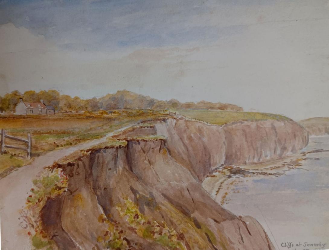
inscribed and dated "Cliffs at Sewerby Bridlington Aug 28 1875" and signed with initials "LWT"
Tom and Laura Taylor and thence by descent
The foreshore at Sewerby is accessed by a series of steps from the cliff top, a short walk from a large Pay-and-Display car park. We shall begin on a falling tide and examine the stratigraphy in the chalk cliffs which comprise the Flamborough Chalk Formation capped by Quaternary tills and gravels.
At the most westerly point we can examine the site of Sewerby Buried Cliff, first discovered by Clement Reid in 1884 and excavated by Lamplugh. This marks the end of Flamborough Head and the start of Holderness as the pre-glacial chalk cliff continues westwards, inland hidden beneath its cover of drift.
Between the buried cliff and Sewerby Rocks there will be numerous glacial erratics, many of them exotic, which will undoubtedly promote discussion and we will be keeping an eye open for evidence of sponge fossils in the ledges of the wave-cut platform. Our aim will be to locate the position of the Flamborough Sponge Bed (Upper Cretaceous, Flamborough Chalk Formation), several metres of sponge-rich chalk and marl interbeds containing a good range of often well-preserved, three-dimensional specimens.
Sewerby was occupied by an Anglo Saxon settlement and has one of the most significant burial sites. The people were pagans and the cemetery dates to the 6th-7th centuries, making it one of the earliest cemeteries of the Anglo Saxon period. Alongside the dead, objects owned and treasured in life were also buried in the ground. The site was discovered during the building of a modern farmhouse at Home Farm in the mid-1950s and the site was then excavated. Further work took place in the 1970s. Human remains were found with a significant array of brooches, clasp fasteners for cloaks, beads and weapons.
These grave goods are kept in the collection at Sewerby Hall. The Sewerby site represents an important archaeological resource for understanding early Anglo Saxon life, social structure and cultural practices. We believe, for instance, that sacrificial burials were practised: grave 49, that of a high-born woman also contained the remains of another person on top, suggesting this was the body of a servant. The second skeleton was discovered face down with limbs at awkward angles. There was also a heavy stone on the lower back indicating that this individual was still alive when buried. An alternative explanation is that the woman was a 'witch' or had committed a crime of some kind.
The Anglo Saxon kingdoms of Deira and Bernicia were united under the reign of King Aethelfrith in 604, eventually becoming the single kingdom of Northumbria under King Edwin. In 627 he was baptised a Christian by Paulinus at his capital city of Eoforwic - York and so began the slow process of England's conversion to Christianity.
As Christianity became widely adopted, the pagan burial practices became outmoded and sites like Sewerby's Anglo Saxon cemetery were abandoned. Nevertheless, its importance is recognised as it is scheduled under the Ancient Monuments and Archaeological Areas Act 1979.
Bridlington is a seaside town and civil parish in the East Riding of Yorkshire, England. It is on the Holderness part (Flamborough Head to the Humber estuary) of the Yorkshire Coast by the North Sea. The town is about 28 miles (45 km) north of Hull and 34 miles (55 km) east of York. The stream called Gypsey Race flows through the town and enters the North Sea at the harbour.
The Priory Church of St Mary and associated Bayle (or gate) are Grade I listed buildings on the site of an Augustinian Priory. As a sea-fishing port, the town is known for shellfish, and is the largest lobster port in Europe, with over 300 tonnes of the crustaceans landed there each year. It has been termed the "Lobster Capital of Europe". Alongside manufacturing, retail and service firms, its main trade is summer tourism. It holds one of the UK's coastal weather stations.
Archaeological evidence shows habitation of the area around the Bronze Age and Romano Britain era. The date of earliest habitation at Bridlington is unknown, but the 2.5-mile (4 km) man-made Danes Dyke at nearby Flamborough Head goes back to the Bronze Age.
A Roman road from York, now Woldgate, can be traced across the Yorkshire Wolds into the town. Roman coins have been found: two hoards in the harbour area, along with two Greek coins from the second century BC — suggesting the port was in use long before the Roman conquest of Britain.
In the fourth century AD, Count Theodosius set up signal stations on the North Yorkshire coast to warn of Saxon raids. It has been suggested that the current town was built near the site of a Roman maritime station called Gabrantovicorum. In the early second-century, Ptolemy described what was possibly Bridlington Bay in his Geography as Γαβραντουικων Ευλίμενος κόλπος "Gabrantwikone bay suitable for a harbour". No sheltered ancient harbour has been found, coastal erosion will have destroyed traces of any Roman installation near the harbour.
Another station at Flamborough Head is also believed to have had one – probably on Beacon Hill (now a gravel quarry) from where Filey, Scarborough Castle and the Whitby promontory can be seen. Another suggestion has been a line of signal stations stretching south round Bridlington Bay. A fort at Bridlington would have made a centre of operations for these. This counterpart to the northern chain would have guarded a huge accessible anchorage from barbarian piracy.
Near Dukes Park are two bowl barrows known as Butt Hills, designated ancient monuments in the National Heritage List for England of Historic England. Nearby are remains of an Anglo-Saxon cemetery on a farm outside Sewerby. The several suggested origins all trace the name to the Anglo-Saxon custom of matching a personal name with a settlement type. Here the personal names advanced include Bretel, Bridla and Berhtel, attached to -ingtūn, an Old English term for a small farming community. In 1072 the area was given to Gilbert de Gant, uncle of the later king King Stephen, it was inherited by his son Walter and thereafter appears to follow the normal descent of that family.
The 1086 Domesday Book is earliest known reference to Bridlington being record as Bretlinton: the settlement has since been called Berlington, Brellington and Britlington before gaining its present name in the 19th century. The Domesday Book records that Bretlinton was the Hunthow Wapentake's meeting point (the wapentake later merged with neighbouring wapentakes to form the Dickering Wapentake). The wapentake was held by Earl Morcar, it later passed to William the Conqueror by forfeiture. It also records the effect of the Harrying of the North: the annual value of the land had fallen from £32 in the time of Edward the Confessor to eight shillings (£0.40) at the time of the survey, comprising two villeins and one socman with one and a half Carucate, the rest being waste.
Walter de Gant founded an Augustinian priory on the land in 1133, confirmed by Henry I in a charter. Several succeeding kings confirmed and extended Walter de Gant's gift: King Stephen granted an additional right to have a port, King John in 1200 gave permission for a weekly market and an annual fair, and Henry VI allowed three annual fairs, on the Nativity of Mary and the Deposition and Translation of St John of Bridlington in 1446. In 1415 Henry V visited the Priory to give thanks for victory at the Battle of Agincourt.
After the Dissolution of the Monasteries, the manor of Bridlington remained with the Crown until 1624, when Charles I passed it to Sir John Ramsey, who had recently been created Earl of Holderness. In 1633, Sir George Ramsey sold the manor to 13 inhabitants of the town, on behalf of all the manor tenants. In May 1636, a deed was drawn up empowering the 13 men as Lords Feoffees or trust holders of the Manor of Bridlington.
.jpg)
The town began to grow in importance and size around the site of the dispersed priory. In 1643 Queen Henrietta Maria of France landed there with troops to support the Royalist cause in the English Civil War, before moving on to York, which became her headquarters.
,_Yorkshire,_England-LCCN2002708301.jpg)
The town was originally two settlements: the Old Town about one mile (1.6 km) inland and the Quay area where the modern harbour lies. In 1837, an Act of Parliament enabled the wooden piers to be replaced with two stone piers to the north and south. Apart from landing fish, the port was used to transport corn: the 1826 Corn Exchange can still be seen in Market Place. There used to be mills in the town for grinding it, which led to some breweries starting up locally.
In the Second World War, Bridlington suffered several air raids that caused deaths and much bomb damage. The Royal Air Force had training schools in the town collectively known as RAF Bridlington, with one unit, No. 1104 Marine Craft Unit, continuing until 1980. Like most industry, these had petered out by the late 20th century.
Bridlington is within the unitary authority of the East Riding of Yorkshire. Its three wards are Bridlington North, Bridlington South and Bridlington Old Town and Central, returning eight councillors out of 67. The civil parish consists of the town of Bridlington and the villages of Bessingby and Sewerby. It is run by a town council of twelve councillors, of which the three wards each return four.
The Town Council coat of arms is described as:
Per Sable and Argent three Gothic Capital letters B counterchanged on a Chief embattled of the second two Barrulets wavy Azure and for the Crest Issuant from a Coronet composed of eight Roses set upon a rim of a Sun rising Gules.
with the motto:
Signum Salutis Semper
meaning Always the bringer of good health.
Bridlington lies in the large East Yorkshire parliamentary constituency that covers the mostly rural, northern part of the county, including the towns of Driffield, Market Weighton and Pocklington. Its size and shape correspond to the East Yorkshire/North Wolds District under the earlier county of Humberside.
The town has been subject to several changes in parliamentary representation. From 1290 to 1831 it was part of the large Yorkshire constituency, sending two members until 1826, when it gained an additional two. Thereafter it was part of the East Riding of Yorkshire constituency until 1885, returning two members. Further reform reduced the boundaries again, to a single-member Buckrose seat until 1950. From 1950 to 1997, Bridlington had its own MP, until reform extended the boundary to include more countryside, as the single-seat East Yorkshire constituency.
Bridlington was designated a municipal borough in 1899. Local government reorganisation in 1974 included it in the new county of Humberside, which caused resentment among residents against being excluded from Yorkshire. The town became the administrative centre of a local government district, initially called the Borough of North Wolds but later changed to the Borough of East Yorkshire. The district disappeared when the county of Humberside was abolished in the 1990s, the new East Riding of Yorkshire unitary authority absorbing it and the neighbouring county districts, and Bridlington no longer having any formal local-government administrative status above town-council level.
Bridlington lies 19 miles (31 km) north-north-east of Beverley, 17 miles (27 km) south-east of Scarborough, 11 miles (18 km) north-east of Driffield and 24 miles (39 km) north of Kingston upon Hull, the principal city in the county. It is 179 miles (288 km) north of London. The height above sea level ranges from the beaches to 167 feet (51 m) on Bempton Lane on the outskirts. The Gypsey Race river flows through the town, the last 1⁄2 mi (800 m) being below ground from the Quay Road Car Park. The solid geology of the area is mainly from the Cretaceous period, consisting of Chalk overlain by Quaternary Boulder clay. The chalk is exposed as the land rises to the north of the town, where a cliff, probably formed in the last interglacial, extends inland at right angles to the present sea cliff, and forms the promontory of Flamborough Head.
Bridlington is in an area said to have the highest coastal erosion rate in Europe. Southwards the coast becomes low, but northwards it is steep and very fine, where the great spur of Flamborough Head projects eastwards. The sea front is guarded by a sea wall and a wide beach with wooden groynes to trap the sand. Offshore, the Smithic Sands sandbank stretches out into the bay, as an important habitat for many marine species.Bridlington north and south beaches have won EU environmental quality awards over the years.
Laura Wilson Barker (6 March 1819 – 22 May 1905), was a composer, performer and artist, sometimes also referred to as Laura Barker, Laura W Taylor or "Mrs Tom Taylor".
She was born in Thirkleby, North Yorkshire, third daughter of a clergyman, the Rev. Thomas Barker. She studied privately with Cipriani Potter and became an accomplished pianist and violinist. As a young girl Barker performed with both Louis Spohr and Paganini. She began composing in the mid-1830s - her Seven Romances for voice and guitar were published in 1837. From around 1843 until 1855 she taught music at York School for the Blind. During this period some of her compositions - including a symphony in manuscript, on 19 April 1845 - were performed at York Choral Society concerts.
On 19 June 1855 she married the English dramatist, critic, biographer, public servant, and editor of Punch magazine Tom Taylor. Barker contributed music to at least one of her husband's plays, an overture and entr'acte to Joan of Arc (1871), and provided harmonisations as an appendix to his translation of Ballads and Songs of Brittany (1865).
Her other works include the cantata Enone (1850), the violin sonata A Country Walk (1860), theatre music for As You Like It, (April 1880), Songs of Youth (1884), string quartets, madrigals and solo songs. Her choral setting of Keats's A Prophecy, composed in 1850, was performed for the first time 49 years later at the Hovingham Festival in 1899. The composer was present.
Several of Barker's paintings hang at Smallhythe Place in Kent, Ellen Terry's house.
Barker lived with her husband and family at 84 Lavender Sweep, Battersea. There were two children: the artist John Wycliffe Taylor (1859–1925), and Laura Lucy Arnold Taylor (1863–1940). The Sunday musical soirees at the house attracted many well-known attendees, including Lewis Carroll, Charles Dickens, Henry Irving, Charles Reade, Alfred Tennyson, Ellen Terry and William Makepeace Thackeray.
Tom Taylor died suddenly at his home in 1880 at the age of 62. After his death, his widow retired to Porch House, Coleshill in Buckinghamshire, where she died on 22 May 1905, aged 86.