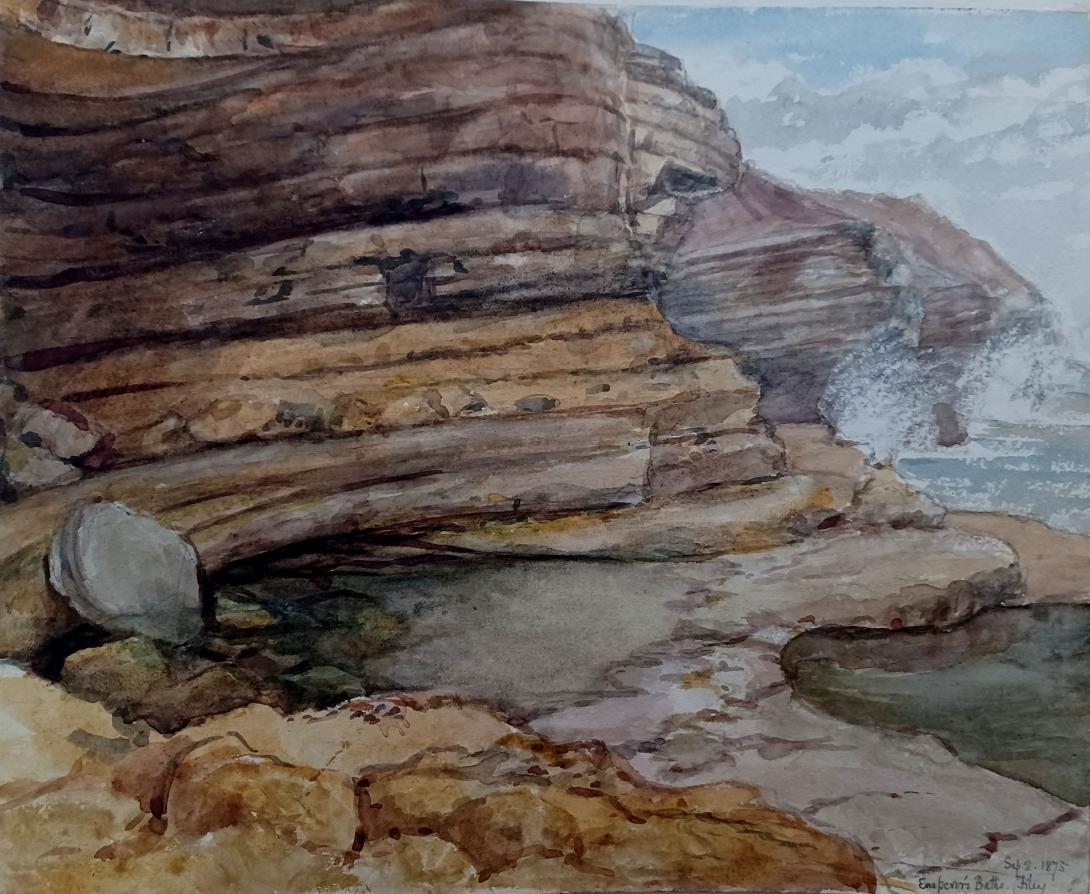
inscribed and dated "Emperor's Baths Filey Sep 2nd 1875" and sigend with initials "LWT"
Tom and Laura Taylor and thence by dsecent
Filey Brigg is a long narrow peninsula situated about a mile north of Filey. Its steep cliffs are 20 metres high and consist of Jurassic limestone and sandstone and Quaternary boulder clay. The landward end of the peninsula of Filey Brigg is known as Carr Naze, whilst the long neck of rock at the seaward end is called the Brigg. The biology and geology of Filey Brigg make it a Site of Special Scientific Interest. The remains of a Roman signal station have been found on The Brigg.
So what did the Roman’s ever do for Filey, you might ask? Well, apart from a signal station, some pottery at Primrose Valley, possibly a road from Malton, maybe a jetty, but probably not an Emperor’s bath, not a lot really. Wander in the Crescent Gardens and you will see stones from Filey’s Roman signal station. To paraphrase Frank Sinatra, five stones in the garden is a poor reflection of one of the greatest civilisations in human history.
It is fair to say that the Roman’s trod lightly at Filey, at least as far as we know. Coastal erosion may well have swept several pages from the history book. We can safely say that the so-called Emperor’s Bath on the north side of Carr Naze has very little to do with the Emperor Constantine and more to do with Victorian quarrying and coastal erosion. Sadly, the Emperor Constantine almost certainly did not nip across to Filey to enjoy a celebratory bathe in the frigid waters of the North Sea after he was proclaimed Emperor of the Roman Empire at York in 306.
Whilst we are out on Carr Naze we may as well examine another claimed Roman artefact, the fabled ‘Roman Jetty’ that emerges during the Spring Tides. In his peerless book, Filey, from fishing village to Edwardian resort, Michael Fearon dismisses the ideas as ‘fanciful’. The ‘jetty’ is best viewed from the top of Carr Naze, it points towards Bempton Cliffs, its angle being quite distinct from the Brigg itself. Its origins has intrigued generations, but there is no archaeological evidence to support its supposed Roman origins. As far back as 1828 in his book The History and Antiquities of Filey in the County of York, John Cole claimed that the jetty had been constructed at ‘some very remote period’. However, at present the consensus seems to be that the ‘jetty’ is not man-made, but is a ‘cranch’, an accumulation of boulders built up by the actions of the tide. At least that was the view of Frank Gerald Simpson Yorkshire Roman Antiquities Committee and Thomas Sheppard of Hull Museum when they examined the site in 1922. However, in 1972 the Yorkshire Federation of Sub-Aqua Clubs sent no less than sixty divers in search of the jetty’s Roman origins. Unfortunately no definite conclusions were arrived at.
Of course, the Roman’s built their famous roads, but would they have built a road to serve a signal station? Given that the signal station could have been easily reached by sea, why commit huge resources to building a road? Of course, it may well be that there were other Roman sites in the vicinity that have either not yet been rediscovered or have succumbed to coastal erosion. Hints of a road from the fort and settlement at Malton (the fabulously named Derventio Brigantium) have been found over the years. In 1862 during the installation of a new drain at Norton, a cobbled road and the neck of a Roman jar was found; hinting at an eastbound road. It has been claimed that a Roman road ran south of the present day A64 and A1039, before running north of Muston and entering Filey through what is now the Wharfedale estate. Several speculative maps have been drawn up, but precious little evidence has been unearthed.
Francis Haverfield, the renowned ‘father of Romano-British Archaeology’, said that he ‘could never find any trace of a Roman road in Filey’. Ancient roads have been unearthed, such as in 1898 when, during the laying of a water main, a cobbled road was revealed that had traces of cement used in it; apparently the Roman’s were famous for the use of cement in their roads. In 1935 the laying of electric cables on Station Road revealed a road comprised of large cobbles. However, the Roman’s did not use large cobbles, so the road was likely to be from another era. Two years later in 1937, during work on the railway level crossing another section of road came to light. Unfortunately, there is little detail as to what exactly was found and some reports of the time suggest that the road was post-Medieval.
More recently Roman pottery was discovered by the York Archaeological Trust whilst they were working on land at the junction of Queen Street and Reynolds Street. In 1924 fragments of Roman pottery was discovered on the south side of Primrose Valley. Apparently the finds corresponded exactly with the finds at the signal station on Carr Naze.
Hints, but no more than that. However, at least the famous signal station is grounded in historical fact. It was the southern-most signal station of five along the Yorkshire coast: the others being Huntcliff near Saltburn; Goldsborough, near Whitby; Ravenscar; and Castle Hill at Scarborough. The Filey station was in use from roughly 375-410 AD. There was a beacon on top of a tower, which would be lit if enemy ships were seen approaching. Landslips have provided evidence of the station, but also threaten to wipe it from the map. Indeed, the signal station was rediscovered in November 1857 after a landslip had revealed the site. An archaeological investigation followed and five stones recovered today stand in the Crescent Gardens. One of the stones has a depiction of what appears to be a hound chasing a stag. The site of the signal station has been further investigated by digs in 1927 and in 1993-4. Quite a number of artefacts were found, including bronze coins, pottery and animal bones. The highlight of the finds was a three foot high bronze statue of the god Mercury, it can be viewed in the Rotunda Museum at Scarborough. Today there is an explanatory board telling the story of the signal station.
Filey Brigg is a long narrow peninsula situated about a mile north of Filey, North Yorkshire. Its steep cliffs are 20 metres high and consist of a variety of material, from pure sandstone to pure limestone.
Filey Brigg is a long narrow peninsula situated about a mile north of Filey, North Yorkshire. Its steep cliffs are 20 metres high and consist of a variety of material, from pure sandstone to pure limestone. The landward end of the peninsula of Filey Brigg is known as Carr Naze, whilst the long neck of rock at the seaward end is called the Brigg. In the early 1970s the fields on top of the Brigg were turned into Filey Brigg Country Park. The biology and geology of Filey Brigg place it among Sites of Special Scientific Interest in North Yorkshire.
The first record of Filey Brigg's ancient history was made by a local antiquarian, Dr Cortis (MD), who excavated a Roman signal station in 1857. In November that year he delivered a lecture to Filey's antiquarians in which he enumerated a number of findings made by "a painter belonging to Filey, named Wilson," who had found large quantities of Roman pottery, bones and charred wood in the area of Carr Naze on the northern side of Filey Bay. The findings encouraged more excavations, the result of which was five large stones believed to be altars or bases of pillars, a dog chasing a stag being carved on one of them. Cortis also reported that near one of the stones an inscription had been found bearing part of two lines:
CÆSAR S E
Q V A M . S P E
Further investigations conducted in 1920 resulted in the belief that the five stones found by Cortis were foundations of a wooden watchtower. However no further remains are visible nowadays because of cliff erosion. It was concluded that the signal station was erected in the late 4th century and was abandoned or plundered around 400 A.D. The five stones can now be seen in the Filey Crescent Gardens.

The existence of the entire structure of Filey Bay and the Brigg is caused by the fact that the rock on the south side of the Brigg slid down, causing the overlying clay to lie either at or below the level of the sea, which eroded it to form Filey Bay. The hard rock on the northern side juts out to form the Brigg. The structure still erodes and large rock slips caused by constant rapid erosion of the clay cliffs of Carr Naze have been witnessed. The last one occurred in 1869 and took away several hundred metres of the Naze.
The rocks of Filey Brigg as well as the intertidal zone attract numerous species of birds, such as oystercatchers, redshanks and purple sandpipers, which visit the shoreline in nationally significant numbers during the winter.
There are two legends concerning the formation of the long ridge of rocks known as Filey Brigg. According to one of them it was built by the Devil, who, having lost his hammer in the sea, reached for it with his hand but caught a fish instead. The Devil exclaimed, "Hah! Dick!", which accounts for the name of the fish – haddock. Since then Filey Brigg has carried the marks of the Devil's grasp on its shoulders.
Another legend states that the rocks were the bones of a dragon, which terrorized the area but was outsmarted by the townsfolk, who drowned it when it dived into the sea to wash parkin (a Yorkshire cake) from between its teeth.
On the north side of Flamborough Head lies Thornwick Bay, a bay with a rock beach surrounded by cliffs. The second part of the name Thornwick comes from the Old Norse word vík ('bay') (meaning that the modern name Thornwick Bay is tautologous). At the north side of the bay lies Thornwick Nebb, the final part of which comes from Old Norse neb ('promontory').
A plaque at Thornwick Bay commemorates the 1952 loss of Robert Redhead, the bowman of the Bridlington lifeboat, while attempting to rescue two girls, Joan Ellis and Gillian Fox, from drowning.
Flamborough Head (/ˈflæmbərə/) is a promontory, 8 miles (13 km) long on the Yorkshire coast of England, between the Filey and Bridlington bays of the North Sea. It is a chalk headland, with sheer white cliffs. The cliff top has two standing lighthouse towers, the oldest dating from 1669 and Flamborough Head Lighthouse built in 1806. The older lighthouse was designated a Grade II* listed building in 1952 and is now recorded in the National Heritage List for England, maintained by Historic England. The cliffs provide nesting sites for many thousands of seabirds, and are of international significance for their geology.
Flamborough Head has been designated a Special Area of Conservation (SAC) by the British Government's Joint Nature Conservation Committee (JNCC). (Special Areas of Conservation are strictly protected sites designated under the European Community Habitats Directive, which requires the establishment of a European network of important high-quality conservation sites to make a significant contribution to conserving the 189 habitat types and 788 species identified in Annexes to this Directive.) Flamborough Outer Headland is an 83 hectares (210 acres) Local Nature Reserve. Yorkshire Wildlife Trust manages the Flamborough Cliffs Nature Reserve, located on the headland.
The cliffs at Flamborough Head are designated a Site of Special Scientific Interest for both geological and biological significance. First designated in 1952, the SSSI area extends from Sewerby round the headland to Reighton Sands. The estimated 200,000 nesting seabirds, including one of only two mainland British gannetries, are the most notable biological feature.

![]()
Flamborough Head in the East Riding of Yorkshire
The headland is the only chalk sea cliff in the north. The coastline within the SSSI has strata from the upper Jurassic through to top of the Cretaceous period, and the headland exhibits a complete sequence of Chalk Group North Sea Basin strata, dated from 100 to 70 million years ago. The various chalk deposits are known as the Ferriby, Welton, Burnham and Flamborough Chalk. The dramatic white cliffs contrast with the low coast of Holderness to the south, where the chalk is deeply buried and the glacial boulder clay above erodes very readily. The chalk cliffs have a larger number and a wider range of cave habitats at Flamborough than at any other chalk site in Britain, the largest of which are known to extend for more than 50 metres from their entrance on the coast. There are also stacks, natural arches and blowholes. The site is identified as being of international importance in the Geological Conservation Review.

Seabirds such as northern gannets, kittiwakes and Atlantic puffins breed abundantly on the cliffs. Bempton Cliffs, on the north side of the headland, has an RSPB reserve and visitor centre.
The shooting of seabirds at Flamborough Head was condemned by Professor Alfred Newton in his 1868 speech to the British Association for the Advancement of Science. Local MP Christopher Sykes introduced the Sea Birds Preservation Act 1869, the first Act to protect wild birds in the United Kingdom. Shooting continued, with an 1886 edition of The Cornishman newspaper reporting the enormous flocks of sea birds are affording sport, with the fisherman killing the birds for selling to taxidermists; two boatmen were bagging a hundred birds daily.
Because it projects into the sea, Flamborough Head attracts many migrant birds in autumn, and is a key point for observing passing seabirds. When the wind is in the east, many birders watch for seabirds from below the lighthouse, or later in the autumn comb the hedges and valleys for landbird migrants. Flamborough Head has a bird observatory.
A Franco-American squadron fought the Battle of Flamborough Head with a pair of Royal Navy frigates in the American Revolutionary War on 23 September 1779. In the engagement, USS Bonhomme Richard and Pallas, with USS Alliance, captured HMS Serapis and HM hired armed ship Countess of Scarborough, the best-known incident of Captain John Paul Jones's naval career. The toposcope at the lighthouse commemorates the 180th (1959) anniversary of the battle.

Danes Dyke is a 2-mile (3.2 km) long ditch that runs north to south isolating the seaward 5 square miles (13 km2) of the headland. The dyke and the steep cliffs make the enclosed territory and its two boat launching beaches, North and South Landings, easily defended. Despite its name, the dyke is prehistoric in origin, and Bronze Age arrowheads were found when it was excavated by Pitt-Rivers in 1879. It is a Local Nature Reserve.
On the north side of Flamborough Head lies Thornwick Bay, a bay with a rock beach surrounded by cliffs. The second part of the name Thornwick comes from the Old Norse word vík ('bay') (meaning that the modern name Thornwick Bay is tautologous). At the north side of the bay lies Thornwick Nebb, the final part of which comes from Old Norse neb ('promontory').
A plaque at Thornwick Bay commemorates the 1952 loss of Robert Redhead, the bowman of the Bridlington lifeboat, while attempting to rescue two girls, Joan Ellis and Gillian Fox, from drowning.
Flamborough Head and the village of Flamborough are the setting for the book Bill Takes the Helm by Betty Bowen. In the book an American boy struggles to save his grandmother's house – in which he, his sister and grandmother are living – from destruction by the sea. He is also desperately trying to get used to England after the death of his mother, who requested in her will that he be sent there.
Flamborough Head was featured on the television programme Seven Natural Wonders as one of the wonders of Yorkshire and briefly in the first series of Coast.
Flamborough Head was featured in the finale of series 3 of the ITV drama Scott & Bailey.
North Landing beach was used as a film location for the 2016 re-make of Dad's Army.
During the evening of 23 August 2006, a lightning bolt hit a buttress on the cliffs, sending 100 tonnes of rock into the sea.
Laura Wilson Barker (6 March 1819 – 22 May 1905), was a composer, performer and artist, sometimes also referred to as Laura Barker, Laura W Taylor or "Mrs Tom Taylor".
She was born in Thirkleby, North Yorkshire, third daughter of a clergyman, the Rev. Thomas Barker. She studied privately with Cipriani Potter and became an accomplished pianist and violinist. As a young girl Barker performed with both Louis Spohr and Paganini. She began composing in the mid-1830s - her Seven Romances for voice and guitar were published in 1837. From around 1843 until 1855 she taught music at York School for the Blind. During this period some of her compositions - including a symphony in manuscript, on 19 April 1845 - were performed at York Choral Society concerts.
On 19 June 1855 she married the English dramatist, critic, biographer, public servant, and editor of Punch magazine Tom Taylor. Barker contributed music to at least one of her husband's plays, an overture and entr'acte to Joan of Arc (1871), and provided harmonisations as an appendix to his translation of Ballads and Songs of Brittany (1865).
Her other works include the cantata Enone (1850), the violin sonata A Country Walk (1860), theatre music for As You Like It, (April 1880), Songs of Youth (1884), string quartets, madrigals and solo songs. Her choral setting of Keats's A Prophecy, composed in 1850, was performed for the first time 49 years later at the Hovingham Festival in 1899. The composer was present.
Several of Barker's paintings hang at Smallhythe Place in Kent, Ellen Terry's house.
Barker lived with her husband and family at 84 Lavender Sweep, Battersea. There were two children: the artist John Wycliffe Taylor (1859–1925), and Laura Lucy Arnold Taylor (1863–1940). The Sunday musical soirees at the house attracted many well-known attendees, including Lewis Carroll, Charles Dickens, Henry Irving, Charles Reade, Alfred Tennyson, Ellen Terry and William Makepeace Thackeray.
Tom Taylor died suddenly at his home in 1880 at the age of 62. After his death, his widow retired to Porch House, Coleshill in Buckinghamshire, where she died on 22 May 1905, aged 86.