" P Yates" and inscribed
Unframed
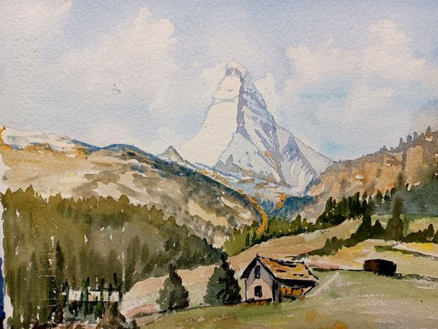
The Matterhorn Cervino is a mountain of the Alps, straddling the main watershed and border between Switzerland and Italy. It is a large, near-symmetric pyramidal peak in the extended Monte Rosa area of the Pennine Alps, whose summit is 4,478 metres (14,692 ft) high, making it one of the highest summits in the Alps and Europe.[note 3] The four steep faces, rising above the surrounding glaciers, face the four compass points and are split by the Hörnli, Furggen, Leone/Lion, and Zmutt ridges. The mountain overlooks the Swiss town of Zermatt, in the canton of Valais, to the north-east and the Italian town of Breuil-Cervinia in the Aosta Valley to the south. Just east of the Matterhorn is Theodul Pass, the main passage between the two valleys on its north and south sides, which has been a trade route since the Roman Era.
The Matterhorn was studied by Horace-Bénédict de Saussure in the late eighteenth century, who was followed by other renowned naturalists and artists, such as John Ruskin, in the 19th century. It remained unclimbed after most of the other great Alpine peaks had been attained and became the subject of an international competition for the summit. The first ascent of the Matterhorn was in 1865 from Zermatt by a party led by Edward Whymper; it ended when four of its seven members fell to their deaths on the descent. This disaster, later portrayed in several films, marked the end of the golden age of alpinism. The north face was not climbed until 1931 and is among the three biggest north faces of the Alps, known as "The Trilogy". The west face, which is the highest of the Matterhorn's four faces, was completely climbed only in 1962. It is estimated that over 500 alpinists have died on the Matterhorn, making it one of the deadliest peaks in the world.
The Matterhorn is mainly composed of gneisses (originally fragments of the African Plate before the Alpine orogeny) from the Dent Blanche nappe, lying over ophiolites and sedimentary rocks of the Penninic nappes. The mountain's current shape is the result of cirque erosion due to multiple glaciers diverging from the peak, such as the Matterhorn Glacier at the base of the north face. Sometimes referred to as the Mountain of Mountains the Matterhorn has become an iconic emblem of the Alps in general. Since the end of the 19th century, when railways were built in the area, the mountain has attracted increasing numbers of visitors and climbers. Each year, numerous mountaineers try to climb the Matterhorn from the Hörnli Hut via the northeast Hörnli ridge, the most popular route to the summit. Many trekkers also undertake the 10-day-long circuit around the mountain. The Matterhorn has been part of the Swiss Federal Inventory of Natural Monuments since 1983.
The Matterhorn has two distinct summits, situated at either end of a 100-metre-long (330 ft) exposed rocky crest which forms the Italian/Swiss border. In August 1792, the Genevan geologist and explorer Horace Bénédict de Saussure made the first measurement of the Matterhorn's height, using a sextant and a 50-foot-long (15 m) chain spread out on the Theodul glacier. He calculated its height as 4,501.7 m (14,769 ft). In 1868 the Italian engineer Felice Giordano measured a height of 4,505 m (14,780 ft) by means of a mercury barometer, which he had taken to the summit. The Dufour map, which was afterwards followed by the Italian surveyors, gave 4,482 m (14,705 ft) as the height of the Swiss summit.
In 1999, the summit height was precisely determined to be at 4,477.54 m (14,690 ft) above sea level by using Global Positioning System technology as part of the TOWER Project (Top of the World Elevations Remeasurement) and to an accuracy of less than one centimetre, which allows future changes to be tracked.
The topographic prominence of the Matterhorn is 1,042 metres (3,419 ft) as the ridge connecting it with a higher summit (in this case the Weisshorn, which is the culminating point of the range west of the Mattertal valley) sinks to a height of 3,436 m (11,273 ft) at the Col Durand, a saddle between the Pointe de Zinal and the Mont Durand. The topographic isolation is 13.9 km (8.6 mi), as the nearest point of higher elevation is the one-metre (3 ft 3 in) higher Western Liskamm.
Considering mountains with a topographic prominence of at least 300 m (980 ft), the Matterhorn is the sixth-highest summit in the Alps and Europe outside the Caucasus Mountains. It is the fifth-highest summit of Valais and Switzerland and the third highest summit of the Aosta Valley and Italy. Locally, it is the third-highest summit in the municipality of Zermatt and the highest summit in the municipality of Valtournenche. On the official International Climbing and Mountaineering Federation list of Alpine four-thousanders, which also includes subsidiary summits of higher mountains such as the nearby Monte Rosa, the Matterhorn is the 12th highest summit in the Alps.
The Matterhorn has a pyramidal shape with four faces nearly facing the four compass points. Three of them (north, east and west) are on the Swiss side of the border and watershed (Mattertal valley) and one of them (south) is on the Italian side of the border (Valtournenche valley). The north face overlooks the Ober Gabelhorn (7 km away) across the Zmutt Glacier and valley (above Zermatt), the east face overlooks the Gorner Glacier system between the Gornergrat and Monte Rosa (respectively 10 and 17 km away) across the Theodul Pass, the west face overlooks the upper basin of the Zmutt Glacier between the Dent Blanche and the Dent d'Hérens (respectively 7 and 4 km away) and the south face fronts the resort town of Breuil-Cervinia and overlooks a good portion of the Valtournenche. The Matterhorn does not form a perfect square pyramid, as the north and south faces are wider than the west and east faces. Moreover, the latter faces do not actually meet on the summit but are connected by a 100-metre-long horizontal west–east ridge between the north and south faces.
The Matterhorn's faces are steep, and only small patches of snow and ice cling to them; regular avalanches send the snow down to accumulate on the glaciers at the base of each face, the largest of which are the Tiefmattengletscher to the west, part of the Zmutt Glacier, and the Matterhorn Glacier to the north. Smaller glaciers lie at the base of the south face (the Lower Matterhorn Glacier) and the east face (unnamed). In this area, the border between Switzerland and Italy coincides with the main Alpine watershed, separating the drainage basin of the Rhone on the north (Mediterranean Sea) and that of the Po on the south (Adriatic Sea). The north side is drained by the Zmuttbach (west and north faces) and the Gornera through the Furggbach (east face), tributaries of the Rhone through the (Matter) Vispa. The south side and face is drained by the Marmore torrent, a tributary of the Po through the Dora Baltea (or Doire baltée). The Theodul Pass, located on the watershed between the Matterhorn and the Breithorn, at 3,295 metres, is the easiest passage between the two valleys and countries (the slightly lower Furggjoch not being used as a pass). The pass was used as a crossover and trade route for the Romans and the Romanised Celtic population Salassi between 100 BCE and 400 CE. The area is now heavily glaciated and covered on the north side by the Theodul Glacier.
Well-known faces are the east and north, visible from the area of Zermatt, although mostly hidden from the Mattertal by the chain of the Weisshorn. The east face is 1,000 metres high and, because it is "a long, monotonous slope of rotten rocks", presents a high risk of rockfall, making its ascent dangerous. The north face is 1,200 metres high and is one of the most dangerous north faces in the Alps, in particular for its risk of rockfall and storms. The south face, well visible from the Valtournenche, is 1,350 metres high and offers many different routes. The west face, the highest at 1,400 metres, has the fewest ascent routes and lies in a more remote area than the other faces.
The four main ridges separating the four faces are the main climbing routes. The least difficult technical climb and the usual climbing route, the Hörnli ridge (Hörnligrat), lies between the east and north faces and is aligned towards the Oberrothorn above Zermatt. To its west lies the Zmutt ridge (Zmuttgrat), between the north and west faces and aligned towards the Wandfluehorn; this is, according to Collomb, "the classic route up the mountain, its longest ridge, also the most disjointed." The Lion ridge (Cresta del Leone / Arête du lion), lying between the south and west faces and aligned towards the Dent d'Hérens is the Italian normal route and goes across Pic Tyndall; Collomb comments, "A superb rock ridge, the shortest on the mountain, now draped with many fixed ropes, but a far superior climb compared with the Hörnli." Finally the south side is separated from the east side by the Furggen ridge (Furggengrat), which is aligned towards the Klein Matterhorn. It is, according to Collomb, "the hardest of the ridges the ridge still has an awesome reputation but is not too difficult in good conditions by the indirect finish".
While the Matterhorn is the culminating point of the Valtournenche on the south, it is only one of the many 4000 metres summits of the Mattertal valley on the north. Its height is exceeded by four major summits: the Weisshorn (4,505 m), the Dom (4,545 m), the Liskamm (4,527 m) and the second-highest in the Alps, Monte Rosa (4,634 m). This section of the Pennine Alps, including the Matterhorn, the Zinalrothorn, the Dent Blanche, the Dent d'Hérens, the Breithorn, the Strahlhorn, the Rimpfischhorn and the Alphubel, concentrates most of western Europe's highest mountains and forms a crown of peaks around Zermatt. The deeply glaciated region between the Matterhorn and Monte Rosa (named Dent Blanche-Matterhorn-Monte Rosa) is listed in the Federal Inventory of Landscapes and Natural Monuments since 1983.