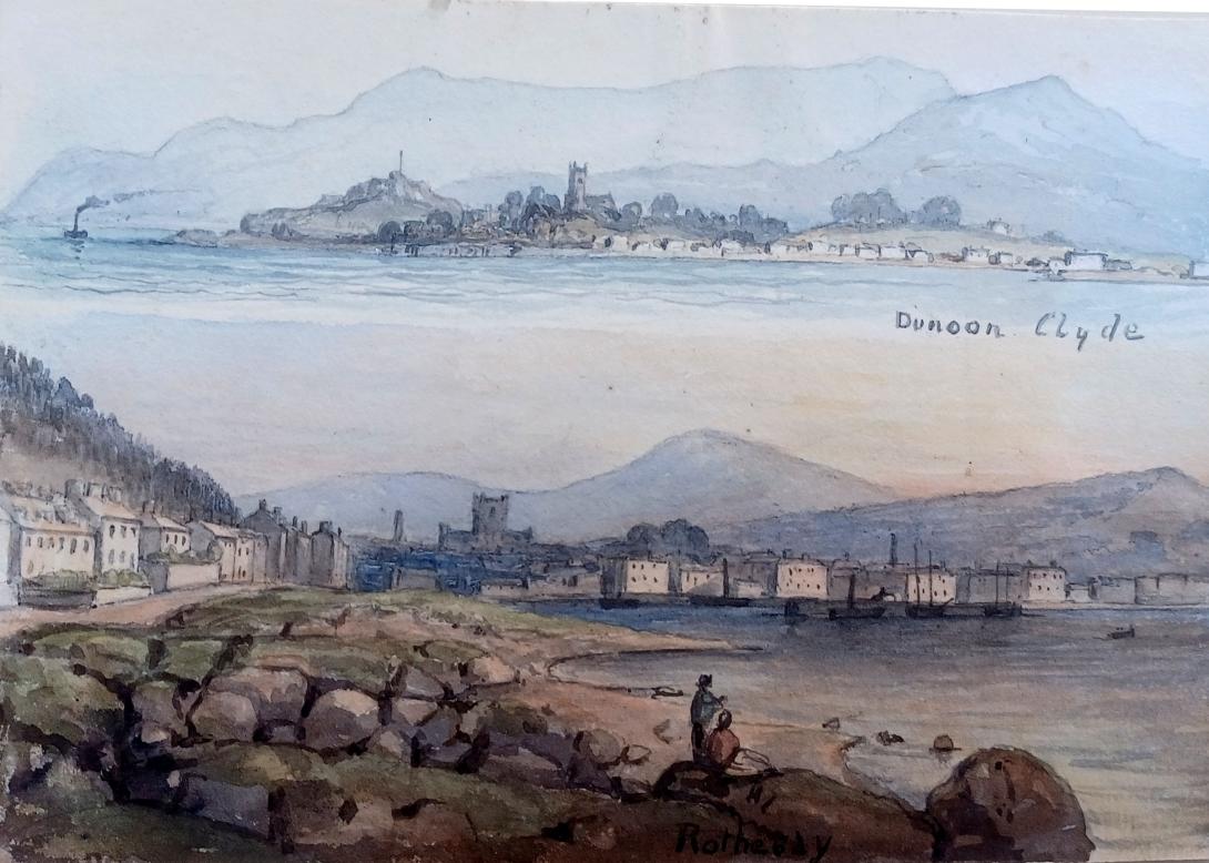

inscribed " Dunoon Rothesay" a page from an album inscribed in the frontispage "F W Staines 3 Uplands St Leonards on Sea"
Amelia Jackson, Nee Staines (1842 – 1925) and thence by descent
Dunoon Dùn Omhain is the main town on the Cowal peninsula in the south of Argyll and Bute, Scotland. It is located on the western shore of the upper Firth of Clyde, to the south of the Holy Loch and to the north of Innellan. As well as forming part of the council area of Argyll and Bute, Dunoon also has its own community council. Dunoon was a burgh until 1976.
The early history of Dunoon often revolves around two feuding clans: the Lamonts and the Campbells. Dunoon was a popular destination when travel by steamships was common around the Firth of Clyde; Glaswegians described this as going doon the watter. This diminished, and many holidaymakers started to go elsewhere as roads and railways improved and the popularity of overseas travel increased.
In 1961, during the height of the Cold War, Dunoon became a garrison town to the United States Navy. In 1992, shortly after the dissolution of the Soviet Union, they closed their Holy Loch base in Sandbank, and neighbouring Dunoon suffered an economic downturn. Since the base's closure, the town and surrounding area are again turning to tourism, marketing to outdoor enthusiasts and wildlife lovers, as well as promoting festivals and competitions. The largest annual event held in the town is the Cowal Highland Gathering, which has been held since 1894.The Royal National Mòd has been also been held in the town.
Dunoon Castle was built on a small, partly artificial, conical hill beside the Firth of Clyde in the 12th century, of which low walls remain. It eventually became a royal castle with the Earls of Argyll (Campbells) as hereditary keepers, paying a nominal rent of a single red rose to the sovereign. Mary, Queen of Scots visited Dunoon Castle on 26 July 1563 and granted several charters during her visit. In 1646 the Dunoon massacre of members of Clan Lamont by members of Clan Campbell took place. The castle was destroyed during Argyll's Rising, a rebellion in 1685 against James VII.
In the early 19th century, the town's main street, Argyll Street, stopped at Moir Street. Instead of continuing to Dunoon Pier, it turned right at today's Sinbad's Bar. Before Dunoon Burgh Hall was built, beginning in 1873, the land was an open field, owned by James MacArthur Moir, leading to an area known as the Gallowhill. There were no streets and houses between Argyll Street and Edward Street. Argyll Street, roughly as it is seen today, was completed by 1870. Moir donated some of his land for the building of the Burgh Hall, but he did not get to see its completion; he died by suicide in 1872.
Dunoon in the 21st century is overlaid with the ghost of a town which, in 1885, possessed two banks, 21 insurance agencies, 10 hotels, a gas company, two bowling greens, three weekly papers, the West of Scotland Convalescent Sea-side Homes (complete with Romanesque hydropathic spa) and the lavishly appointed second homes of some of Scotland's most successful people.
— Saving the Hall (Jay Merrick, 2017)
The two banks mentioned above were the Union Bank of Scotland and the City of Glasgow Bank.[12] The hydropathic spa, meanwhile, was "an elegant new baths building, named Ardvullin, erected a little to the north of the village as a hydropathic establishment, where baths - hot, cold, artificial salt, and Turkish — may be had at moderate charges."
Many of the town's early villas had their own private bathing ground or boxes.
The best bathing place for ladies is the West Bay. Gentlemen's bathing places: Rocks, foot of Castle Hill, deep at all states of the tide. Sand: beyond Baugie Burn, beginning of Bullwood, shallow and sandy. Rocks: behind Argyll Hotel, available only at high water. Kirn Pier and Hunters Quay, deep water.
— Colegate's Guide to Dunoon, Kirn, and Hunter's Quay (John Colegate, 1868)
The population of the united parishes of Dunoon and Kilmun in 1861 was 5,444; in 1866 the estimated population of Dunoon, from Baugie Burn to Hunters Quay, was 3,000.

During the Second World War, as the main part of the Firth of Clyde defences, an anti-submarine boom was anchored to the shore in Dunoon. A Palmerston Fort and camp at Ardhallow in the south of the town, provided one of the coastal defence gun emplacements that covered the anti-submarine boom and Firth of Clyde waters. There also was a gun emplacement on top of Castle Hill.
In 1961, as the Cold War intensified, the Holy Loch's importance grew when the U.S. Navy submarine tender USS Proteus brought Polaris ballistic missiles, nuclear submarines to the Firth of Clyde at Sandbank. Campaign for Nuclear Disarmament protesters drew this to the public's attention. Holy Loch was, for thirty years, the home port of US Navy Submarine Squadron 14 and Dunoon, therefore, became a garrison town.
In 1991, the Holy Loch base was deemed unnecessary following the demise of the Soviet Union and was subsequently withdrawn. The last submarine tender to be based there, the USS Simon Lake, left Holy Loch in March 1992, leading to a major and continuing downturn in the local economy.
In May 2012, Dunoon and Campbeltown were jointly named as the rural places in Scotland most vulnerable to a downturn in a report by the Scottish Agricultural College looking at 90 places.
Rothesay is the principal town on the Isle of Bute, in the council area of Argyll and Bute, Scotland. It lies along the coast of the Firth of Clyde. It can be reached by ferry from Wemyss Bay, which offers an onward rail link to Glasgow. At the centre of the town is the 13th-century ruin Rothesay Castle, unique in Scotland for its circular plan.
In modern Scottish Gaelic, Rothesay is known as Baile Bhòid, meaning 'town of Bute'. The English-language name, which was written as Rothersay in 1321, Rosay around 1400, and Rothissaye around 1500, originally referred to the castle. Since the castle was surrounded by a moat connected to the sea, the name may have originally meant 'Rother's Isle' (the Old Norse suffix -ey means "isle"), or it may be an alteration of the Gaelic word rath, meaning 'fort'.

.jpg)

The old town centred on Rothesay Castle, which was built in the 13th century. The castle has long stood in ruins, but it is nevertheless picturesque, and was a focal point for tourists as soon the town began developing into a seaside resort.
Rothesay was the county town in the civil parish of Rothesay, which was located in the former county of Bute. The county historically included the islands of Great Cumbrae, Little Cumbrae and Arran. Rothesay Town Hall and County Buildings overlooks the castle.
During the Victorian era, Rothesay became a popular tourist destination. In particular, it was hugely popular with Glaswegians going "doon the watter" (literally “down the water” – a reference to the waters of the Firth of Clyde). Its wooden pier was busy with steamer traffic. It was home to one of Scotland's many hydropathic establishments, which were in vogue at the time. It also had an electric tramway, the Rothesay and Ettrick Bay Light Railway, which ran across the whole island of Bute and carried passengers to one of the island's largest beaches (the tramway closed in the mid-1930s).
A war memorial designed by Pilkington Jackson was erected in 1922. The Winter Gardens building, erected in 1923, was a centre of many activities in Rothesay in the mid-20th century, hosting some of the best-known music hall entertainers of the day. Rothesay Pavilion, opened in 1938, was another popular attraction. It was an example of International Modernist style architecture, and was designed by the Ayr architect, James Andrew Carrick. Although it later fell into disrepair, it remains a major landmark on the seafront today, and is currently undergoing a complete restoration.
During World War II, Rothesay Bay was the home port of HMS Cyclops, which was the depot ship for the 7th Submarine Flotilla and the training facility for virtually all the British submariners who served during the war. In 1941 and 1942, the Officer Concentration Station Rothesay was also located here.
By the 1960s, Rothesay's heyday as a tourist mecca had largely ended. Inexpensive foreign package holidays had become more popular with UK residents. The Winter Gardens building was closed and lay in disuse for decades. However, it was redeveloped in the 1990s, and is now open as a tourist information and exhibition centre.

The heir to the British throne (currently William, Prince of Wales) is known in Scotland as the Duke of Rothesay. This practice was begun in the late 14th century by Robert III of Scotland, who regularly resided at Rothesay Castle, and first granted the title to his son David in 1398. At that time, the name Rothesay referred to the whole island of Bute, rather than to the town (which was known as Bute-town). The island of Bute (along with the island of Arran) was under the control of Robert III because he had inherited it from his Stewart ancestors. They had owned it ever since King Alexander III of Scotland (having received it from Norway under the Treaty of Perth of 1266) assigned it to Robert III's great-grandfather, Alexander Stewart. The two islands were privately owned by the Stewart family until Robert II (Alexander Stewart's grandson and Robert III's father) inherited the throne from his mother, after which the islands became the property of the Crown.
Once Robert III had conferred this title on his son, the title continued to be given to every heir of the Scottish throne thereafter. Following the Union of the Crowns in 1603, the heir to the British throne was always also formally considered “heir to the Scottish throne” and so acquired the title.
Unlike the title's English equivalent (Duke of Cornwall), the title Duke of Rothesay does not come with any land attached to it in the form of a Duchy. That is because control of the land was instead given to Robert III's half-brother and to the latter's descendants, who acquired the title Marquess of Bute in the 18th century. The current marquess remains the main landlord of the island; his principal seat, Mount Stuart, lies a few miles to the south of Rothesay Castle.

Rothesay was granted a multimillion-pound harbour development project just in time for the arrival of the next generation of lower-firth ferries MV Argyle and MV Bute.
In August 2018, the Donald Campbell Bluebird hydroplane held trials on Loch Fad. It was the first time the vehicle had been in the water since it was recovered from Coniston Water in the Lake District after the 1967 accident in which Campbell was killed.
Francis William Staines was the last of a family of merchants from the City of London. Not only was he a successful businessman but he possessed a large independent fortune, such that he could devote his time to the cultivation of his talents in music and art. He was a brilliant amateur violinist, and also loved to spend much of his time painting. His daughter Amelia and her mother accompanied Mr Staines as he travelled throughout the country finding subjects for his painting. One area of the country that they visited frequently was Scotland and the Lake District, and Amelia grew particularly fond of the dramatic landscape of the Fells. Skelwith Bridge with the view of the hills around it 43 was one of her father’s favourite scenes. He painted landscapes and maritime paintings , exhibited 11 works at the RA including views on the Italian Coast, address in London, Hastings and St Leonards on Sea Susssex.