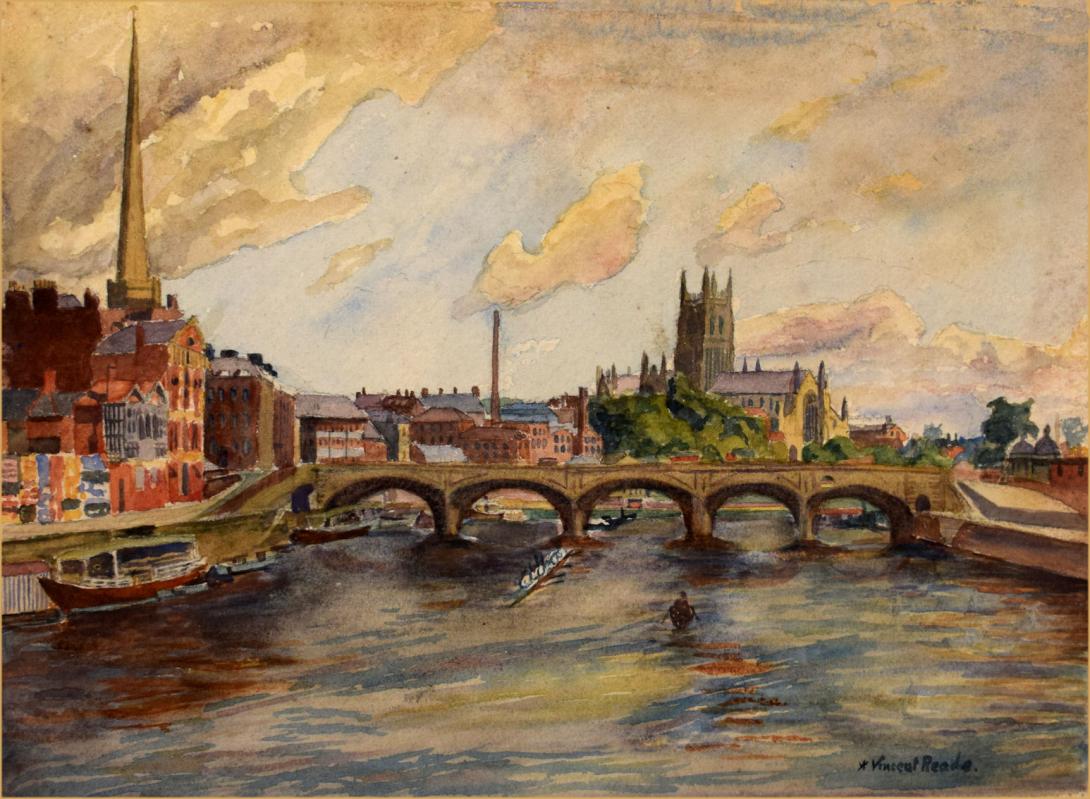
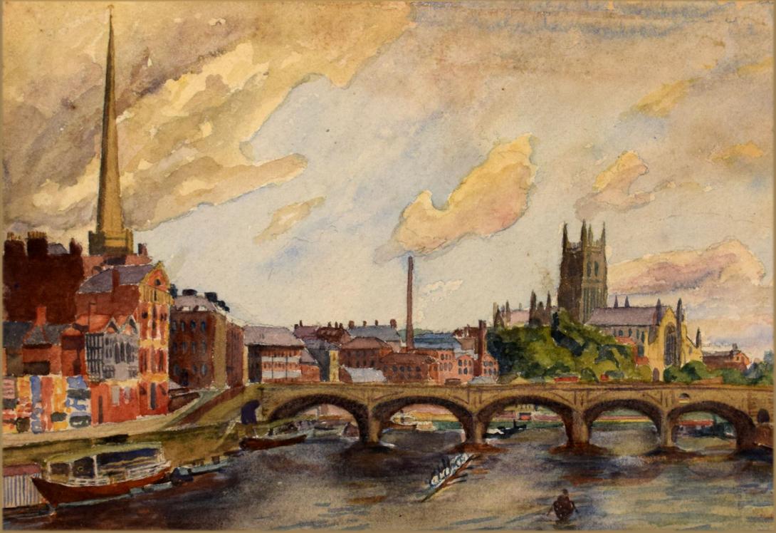
signed "A.Vincent Reade." and further inscribed dated and signed on the reverse " Worcester Cathedral & River Severn / June 20 & 21st - /1928 / A Vincent Reade "
Worcester is a city in Worcestershire, England, 31 miles (50 km) southwest of Birmingham, 101 miles (163 km) west-northwest of London, 27 miles (43 km) north of Gloucester and 23 miles (37 km) northeast of Hereford. The population is approximately 100,000. The River Severn flanks the western side of the city centre, which is overlooked by Worcester Cathedral.
The Battle of Worcester in 1651 was the final battle of the English Civil War, where Oliver Cromwell's New Model Army defeated King Charles II's Royalists. Worcester is known as the home of Royal Worcester Porcelain, composer Edward Elgar, Lea & Perrins, makers of traditional Worcestershire sauce, University of Worcester, and Berrow's Worcester Journal, claimed to be the world's oldest newspaper.
The trade route which ran past Worcester, later forming part of the Roman Ryknild Street, dates to Neolithic times. The position commanded a ford over the River Severn (the river was tidal past Worcester prior to public works projects in the 1840s) and was fortified by the Britons around 400 bc. It would have been on the northern border of the Dobunni and probably subject to the larger communities of the Malvern hillforts.
The Roman settlement at the site passes unmentioned by Ptolemy's Geography, the Antonine Itinerary and the Register of Dignitaries, but would have grown up on the road opened between Glevum (Gloucester) and Viroconium (Wroxeter) in the 40s and 50s ad. It may have been the "Vertis" mentioned in the 7th century Ravenna Cosmography. Using charcoal from the Forest of Dean, the Romans operated pottery kilns and ironworks at the site and may have built a small fort. There is no sign of municipal buildings that would indicate an administrative role.
In the 3rd century, Roman Worcester occupied a larger area than the subsequent medieval city, but silting of the Diglis Basin caused the abandonment of Sidbury. Industrial production ceased and the settlement contracted to a defended position along the lines of the old British fort at the river terrace's southern end.
This settlement is generally identified with the Cair Guiragon listed among the 28 cities of Britain in the History of the Britons attributed to Nennius.This is probably not a British name but an adaption of its Old English name Weorgoran ceaster, "fort of the Weorgoran".
The form of the place-name varied as language and history developed over the centuries, with Early English and subsequent Norman French additions. At its settlement in 7th century by the Angles of Mercia it was known as Weogorna. After centuries of warfare against the Vikings and Danelaw it a centre for the Anglo-Saxon army or here known as Weogorna ceastre (Worcester Camp). At the time of Tenth Century Reformation[clarification needed] to twelfth century, when scholasticism flourished it became approximated to its known linguistic origins[clarification needed] as Wirccester. The county later developed from the shire's name Wigornia from the Anglo-Norman period into the foundations of the Market Fairs during the Henrician and Edwardian parliaments (1216-1377). It was still known as County Wigorn in 1750 when the Shire Courts were still divided into Hundreds.
The Weorgoran (the "people of the winding river") were precursors of Hwicce and probably the West Saxons who entered the area some time after the 577 Battle of Dyrham. In 680, their fort at Worcester was chosen—in preference to both the much larger Gloucester and the royal court at Winchcombe—to be the seat of a new bishopric, suggesting there was already a well-established and powerful Christian community when the site fell into English hands. The oldest known church was St Helen's, which was certainly British; the Saxon cathedral was dedicated to St Peter.
Worcester appears frequently in the historic records prior to the Viking era, often with reference to the church and monastic communities, and showing evidence of extensive ecclesiastical ownership of lands. During King Alfred's reign, the earls of Mercia fortified Worcester "for the protection of all the people" at the request of Bishop Werfrith. It appears that maintenance of the defences was to be paid for by the townspeople. A unique document detailing this and privileges granted to the church also outlines the existence of Worcester's market and borough court, differentiation between church and market quarters within the city, as well as the role of the King in relation to the roads.
Worcester's fortifications would most likely have established the line of the wall that was extant until the 1600s, perhaps excepting the south east area near the former castle. It is referred to as a wall by contemporaries, so may have been of stone.
Worcester was a centre of monastic learning and church power. Oswald of Worcester was an important reformer, appointed Bishop in 961, jointly with York. The last Anglo-Saxon Bishop of Worcester, Wulfstan, or St Wulstan, was also an important reformer, and stayed in post until his death in 1095.
Worcester became the focus of tax resistance against the Danish Harthacanute. Two huscarls were killed in May 1041 while attempting to collect taxes for the expanded navy, after being driven into the Priory, where they were murdered. A military force was sent to deal with the non-payment, while the townspeople attempted to defend themselves by moving to and occupying the island of Bevere, two miles up river, where they were then besieged. After Harthacnut's men had sacked the city and set it alight, agreement was reached.
Worcester was also the site of a mint during the late Anglo-Saxon period, with seven moneyers in the reign of Edward the Confessor. This implies a middling role in trade for the city.
Worcester was, for tax purposes, counted within rural hundreds at the start of the Norman period. It was administratively independent.
Worcester's growth and position as a market town distributing goods and produce came from its river crossing and bridge, and its position on the road network. In the 14th century, the nearest bridges over the Severn were at Gloucester and Bridgnorth. The main road from London to mid-Wales ran through Worcester. The road north west ran to Kidderminster, Bridgnorth and Shrewsbury; and the road north through Bromsgrove connected to Coventry, and towards Derby. The road southward connected to Tewkesbury and Gloucester.
There had been a bridge in Worcester since at least the 11th century; it was replaced in the early 14th century. This bridge, situated below the current Newport Street, had six arches on piers with starlings, and the middle pier had a gatehouse.
The city walls' upkeep was paid for by the residents. The walls included bastions and a watercourse. The course of the wall was fairly irregular. The entrances to the city were through defensive gates, constructed at different times, including St. Martin's Gate in the east, Sidbury Gate to the south, Friar Gate, Edgar Tower and Water Gate; there were six gates by the 16th century.
Worcester was also a centre of medieval religious life; there were several monasteries until the dissolution. These included the Greyfriars, Blackfriars, Penitent Sisters and the Benedictine Priory, now Worcester Cathedral. Monastic houses provided hospitals and education, including Worcester School. The St. Wulstan Hospital was founded around 1085 and was dissolved with the monasteries in 1540. The St. Oswald Hospital was possibly founded by St Oswald. Substantial lands and property in Worcester were held by the church.
Domesday Book also records a considerable number of town houses belonging to rural landowners, presumably used as residences while selling produce from their lands.
In the 1100s, Worcester suffered a number of city fires. The first was on 19 June 1113, destroying town, castle and cathedral, and the second in November 1131.
The following century, the town (then better defended) was attacked several times (in 1139, 1150 and 1151) during the Anarchy, i.e. civil war between King Stephen and Empress Matilda, daughter of Henry I. The 1139 attack again resulted in fire and destruction of a portion of the city, with citizens being held for ransom. Another fire in 1189 destroyed much of the city for the fourth time that century.
Worcester received its first royal charter in 1189. This set out the annual payment made to the Crown as £24 per annum, and set out that the city would deal directly with the Crown's Exchequer, rather than through the county sheriff, who would no longer have general jurisdiction over the city. However, under King John, Worcester's charter was not renewed, which allowed him to levy increasing and arbitrary taxation (tallage) on Worcester, demanding £100 in 1214.
In 1227, under King Henry III Worcester regained its charter and was granted more freedoms. The annual tax was increased to £30. The sheriff was again removed from his role representing the city to the Crown, except in some limited circumstances. A guild of merchants was created, creating a trading monopoly for those admitted. Villeins who resided in the city for a year and day, and were members of the guild, were to be deemed free. The charter was renewed in 1264.[10] Worcester's institutions grew at a slower pace than most county towns and had detectably archaic echoes. It is likely that this is related to the power of the local aristocracy.
Further information: History of the Jews in England (1066–1290) and Jewish community of Worcester § The Jews in Worcester in the Middle Ages Worcester had a small Jewish population by the late 12th century. It was one of a number of places allowed to keep records of debts, in an official locked chest known as an archa. (An archa or arca (plural archae/arcae) was a municipal chest in which deeds were preserved.) Jewish life probably centred around what is now Copenhagen Street.
The Diocese was notably hostile to the Jewish community in Worcester. Peter of Blois was commissioned by a Bishop of Worcester, probably John of Coutances, to write a significant anti-Judaic treatise Against the Perfidy of Jews around 1190.
William de Blois, as Bishop of Worcester, imposed particularly strict rules on Jews within the diocese in 1219. As elsewhere in England, Jews were officially compelled to wear square white badges, supposedly representing tabulae. In most places, this requirement was relinquished as long as fines were paid. In addition to enforcing the church laws on wearing badges, Blois tried to impose additional restrictions on usury, and wrote to Pope Gregory in 1229 to ask for better enforcement of these and further, harsher measures, which the Papacy granted.
A national assembly of Jewish notables was summoned to Worcester by the Crown in 1240 to assess their wealth for taxation; at which Henry III "squeezed the largest tallage of the thirteenth century from his Jewish subjects."
In 1263 Worcester's Jewish residents were attacked by a baronial force led by Robert Earl Ferrers and Henry de Montfort. Most were killed.Ferrers used this opportunity to remove the titles to his debts by taking the archae. The massacre in Worcester was part of a wider campaign by Simon de Montfort's allies at the start of the Second Barons' War. A massacre of London's Jewry also took place during the war.
A few years later, in 1275, those still remaining in Worcester were forced to move to Hereford, as Jews were expelled from towns under the jurisdiction of the queen mother.
Worcester's Ordinances of the sixth year of Edward IV, renewed in 1496–7, and detailed in 82 clauses, give a detailed picture of life and city organisation in the late medieval period. They were to be enforced by the city's bailiffs. Chamberlains received and accounted for rents and other income and the use of common lands within Worcester was set out. Trade regulations covered bread and ale. Others dealt with sanitation, fire regulations and upkeep of the city wall, quays and pavements. Public order and crimes including affray are covered. Citizens were given the privilege of being imprisoned underneath the Guildhall rather than in the town jail, except for the most serious offences.
The cloth industry was also regulated by the Ordinances. Apart from regulation of weights and measures, the ordinances also attempted to protect the artisans engaged in the trade. Payment in kind was banned, with fines of 20 shillings for anyone making payment other than with gold and silver. People were only to be employed if they lived in the city and its suburbs.
Worcester elected members of Parliament at the Guildhall, by the loudest shouting rather than raising of hands. Members of Parliament had to own freehold property worth 40 shillings a year, and be "of good name and fame, not outlawed, not acombred in accyons as nygh as men may knowe, for worshipp of the seid cite". Their wages were levied by the Constable.
The city council was organised by a system of co-option. There were 24 members of the high chamber, and 48 of the lower chamber. Committees appointed the two Bailiffs and made financial decisions, while the two chambers agreed the city's rules, or ordinances.
By late medieval times the population had grown to 1,025 families, excluding the cathedral quarter, so probably stood under 10,000.Worcester had grown beyond the limits of its walls with a number of suburbs.
The manufacture of cloth and allied trades started to become a large local industry. For instance, Leland stated in the mid 1500s that "The welthe of the towne of Worcestar standithe most by draping, and noe towne of England, at this present tyme, maketh so many cloathes yearly as this towne doth."
Through the medieval and early modern period, Worcester developed a system of craft guilds. Guilds regulated who could work in a trade, trade practices and training, and provided social support for members. The city's late medieval ordinances banned tilers from forming a guild, and encouraged tilers to settle in Worcester to trade freely. Roofs of thatch and wooden chimneys were banned in order to reduce fire risks.
The Dissolution saw the Priory's status change, as it lost its Benedictine monks. There were around 36 monks plus the Prior at dissolution in 1540 and some 16 were given pensions immediately or soon after, the rest being employed in the new Deanery. It was necessary to establish 'public schools' to replace monastic education in Worcester as elsewhere. This led to the establishment of King's School. Worcester School continued to teach. St Oswald's Hospital survived the dissolution, later providing almshouses; the charity and its housing survives to the present.
The city was given the right to elect a Mayor and was designated a county corporate in 1621, giving it autonomy from local government. From this point, Worcester was governed by a mayor, recorder and six aldermen. Councillors were selected through co-option.
Worcester in this period contained green spaces such as orchards and fields between its main streets within the city wall boundary, as evidenced by Speed's map of 1610. The walls were still more or less complete at this time, but suburbs had also been established beyond them.
Worcester equivocated about whether to support the Parliamentary cause before the outbreak of civil war in 1642, eventually siding with Parliament. The city was swiftly occupied by the Royalists, who billeted their troops in the city and used the cathedral to store munitions. Essex briefly retook the city for Parliament after the skirmish at the Battle of Powick Bridge, the first engagement of the war. Parliamentary troops then ransacked the cathedral building. Stained glass was smashed and the organ destroyed, along with library books and monuments. Essex was soon forced to withdraw, after the Battle of Edgehill.
The city spent the rest of the war under Royalist occupation, as did the county, for the most part. Worcester was a garrison town and had to bear the expense of sustaining and billeting a large number of Royalist troops. During the Royalist occupation, the suburbs were destroyed to make defence easier. Responsibility for maintenance of defences was transferred to the military command. High taxation was imposed, and many male residents impressed into the army.
As Royalist power collapsed in May 1646, Worcester was placed under siege. Worcester had around 5,000 civilians, together with a Royalist garrison of around 1,500 men, facing a 2,500-5,000 strong force of the New Model Army. Worcester finally surrendered on 23 July, bringing the first civil war to a close in Worcestershire.
In 1651 a Scottish army, 16,000 strong, marched south along the west coast in support of Charles II's attempt to regain the Crown. When the army approached, Worcester's council voted to surrender, fearing further violence and destruction. The Parliamentary garrison withdrew to Evesham in the face of the overwhelming numbers against them. The Scots were billeted in and around the city, again at great expense and causing new anxiety for the residents. The Scots were joined by very limited local forces, including a company of 60 men under Francis Talbot.
The Battle of Worcester (3 September 1651), took place in the fields a little to the west and south of the city, near the village of Powick. Charles II was easily defeated by Cromwell's forces of 30,000 men.[28] Charles II returned to his headquarters in what is now known as King Charles House in the Cornmarket,[29] before fleeing in disguise with Talbot's help to Boscobel House in Shropshire, from where he eventually escaped to France. Worcester was heavily looted by the Parliamentarian army afterwards. The city council estimated £80,000 of damage was done, and the subsequent debts still not recovered into the 1670s.
From 1646 to 1660, the bishopric was abolished and the cathedral fell into disrepair.
After the Restoration in 1660, Worcester cleverly used its location as the site of the final battles of the First Civil War (1646) and Third Civil War (1651) to mount an appeal for compensation from the new King Charles II. As part of this and not based upon any historical fact, it invented the epithet Fidelis Civitas (The Faithful City) and this motto has since been incorporated into the city's coat of arms.
Worcester Guildhall was rebuilt in 1721, replacing the earlier hall on the same site. The now Grade I listed Queen Anne style building was described by Pevsner as "a splendid town hall, as splendid as any of C18 England".
Worcester's historic bridge was replaced, at a cost of £29,843 including its approaches, opening on 17 September 1781. As the town's population expanded, the green areas between the main streets filled with housing and back streets. Nevertheless, the size of the city and suburbs was roughly the same as it was in the early 1600s. Large stretches of the walls of the city had been removed by 1796.
The Royal Worcester Porcelain Company factory was founded by Dr John Wall in 1751. However production ceased in 2009. A handful of decorators are still employed at the factory, and the museum on the site is still open to the public. Since 2015 there has been extensive re-development of the quarter, entirely devoted to housing.
During the late 18th and early 19th centuries, Worcester was a major centre for glove making, employing nearly half the glovers in England at its peak (over 30,000 people). In 1815 the Worcester and Birmingham Canal opened, allowing Worcester goods to be transported to a larger conurbation.
Riots took place in 1831, in response to the defeat of the Reform Bill, reflecting discontent with the city administration and the wider lack of democratic representation. Riots occurred elsewhere, including Bristol. Local government reform took place in 1835, which for the first time created election procedures for councillors, but also restricted the ability of the city to buy and sell property, requiring Treasury permission.
Up until 1835, the legal distinction between a select group of citizens with specific privileges and other residents of the town had survived.
The British Medical Association (BMA) was founded in the Board Room of the old Worcester Royal Infirmary building in Castle Street in 1832. While part of the Royal Infirmary has now been demolished to make way for the University of Worcester's new city campus, the original Georgian building has been preserved. One of the old wards opened as a medical museum, the Infirmary, in 2012.
Railways opened in Worcester in 1850, with Shrub Hill, jointly owned by the Oxford, Worcester and Wolverhampton Railway and Midland Railway, initially running to Birmingham only. Foregate Street was opened in 1860 by the Hereford and Worcester Railway, quickly incorporated into the West Midland Railway. The WMR lines became part of the Great Western Railway after 1 August 1863.
In 1882 Worcester hosted the Worcestershire Exhibition, inspired by the Great Exhibition in London. There were sections for exhibits of fine arts (over 600 paintings), historical manuscripts and industrial items. The profit was £1,867.9s.6d. The number of visitors is recorded as 222,807. Some of the profit from the exhibition was used to build the Victoria Institute in Foregate Street, Worcester. This was opened on 1 October 1896 and originally housed the city art gallery and museum; now located on Foregate Street.
Rail reorganisation in 1922 saw the Midland Railway's routes from Shrub Hill absorbed into the London, Midland and Scottish Railway.
During the Second World War, the city was chosen to be the seat of an evacuated government in case of mass German invasion. The War Cabinet, along with Winston Churchill and some 16,000 state workers, would have moved to Hindlip Hall (now part of the complex forming the Headquarters of West Mercia Police), 3 miles (4.8 km) north of Worcester and Parliament would have temporarily seated in Stratford-upon-Avon. The former RAF station RAF Worcester was located east of Northwick.
A fuel storage depot was constructed in 1941/2 by Shell Mex & BP (later operated by Texaco) for the government on the eastern bank of the River Severn, about one mile south of Worcester. There were six 4,000 ton semi-buried tanks for the storage of white oils. It had no rail or road loading facilities but distribution could be carried out by barge through the Diglis basin and the depot could receive fuel either by barge or the GPSS pipeline network. It was at one time used as a civil reserve storing gas oil and then stored aviation kerosene for USAFE. In the early 1990s it was closed down and was sold for housing in the 2000s.
In the 1950s and 1960s large areas of the medieval centre of Worcester were demolished and rebuilt as a result of decisions by town planners. This was condemned by many such as Nikolaus Pevsner who described it as a "totally incomprehensible... act of self-mutilation". There is still a significant area of medieval Worcester remaining, examples of which can be seen along City Walls Road, Friar Street and New Street, but it is a small fraction of what was present before the redevelopments. The current city boundaries date from 1974, when the Local Government Act 1972 transferred the parishes of Warndon and St. Peter the Great County into the city.
The most famous landmark in Worcester is the imposing Anglican Worcester Cathedral. The current building, officially named the Cathedral Church of Christ and the Blessed Virgin Mary, was known as Worcester Priory before the English Reformation. Construction begun in 1084. Its crypt dates from the 10th century. The chapter house is the only circular one in the country. The cathedral also has the distinction of housing the tomb of King John. Near the cathedral is the spire of St. Andrew's Church, also known as Glover's Needle; the rest of the church was demolished in 1949. The parish church of St. Helen, located on the north side of the High Street, is mainly medieval with a west tower rebuilt in 1813. The east end, refenestration and porch were completed by Frederick Preedy in 1857-63. There was further restoration, by Aston Webb, in 1879-80. It is a Grade II* listed building.
The high-water mark from the flood of 1670, as well as more recent flood levels, are marked on a brass plate located on a wall adjacent to the path along the river leading to the cathedral..
The Hive, situated on the northern side of the River Severn at the former cattle market site, is Worcester's joint public and university library and archive centre, heralded as "the first of its kind in Europe". It is a prominent landmark feature on the Worcester skyline. With seven towers and a golden rooftop, the Hive has gained recognition winning two international awards for building design and sustainability.
There are three main parks in Worcester: Cripplegate Park, Gheluvelt Park and Fort Royal Park, the last being on the site of an English Civil War battle. In addition, there is a large open area known as Pitchcroft to the north of the city centre on the east bank of the River Severn. It is a public space except on days when it is used for horse racing.Gheluvelt Park was opened as a memorial to the participation of the Worcestershire Regiment's 2nd Battalion in the Battle of Gheluvelt during the First World War.
The statue of Sir Edward Elgar, commissioned from Kenneth Potts and unveiled in 1981, stands at the end of Worcester High Street facing the cathedral, only yards from the original location of his father's music shop, which was demolished in the 1960s. Elgar's birthplace is a short way from Worcester, in the village of Broadheath.There are also two large woodlands in the city, Perry Wood and Nunnery Wood. They cover 12 hectares and 21 hectares respectively. Perry Wood is often said to be the place where Oliver Cromwell met and made a pact with the devil. Nunnery Wood is an integral part of the adjacent and popular Worcester Woods Country Park, itself next door to County Hall on the east side of the city.
Albert Vincent Reade was born in 1864, he was a portrait, landscape and still life painter. He studied at the Manchester Academy of Fine Arts and Colarossi's Paris, He exhibited between 1901 and 1933 and lived in Manchester.