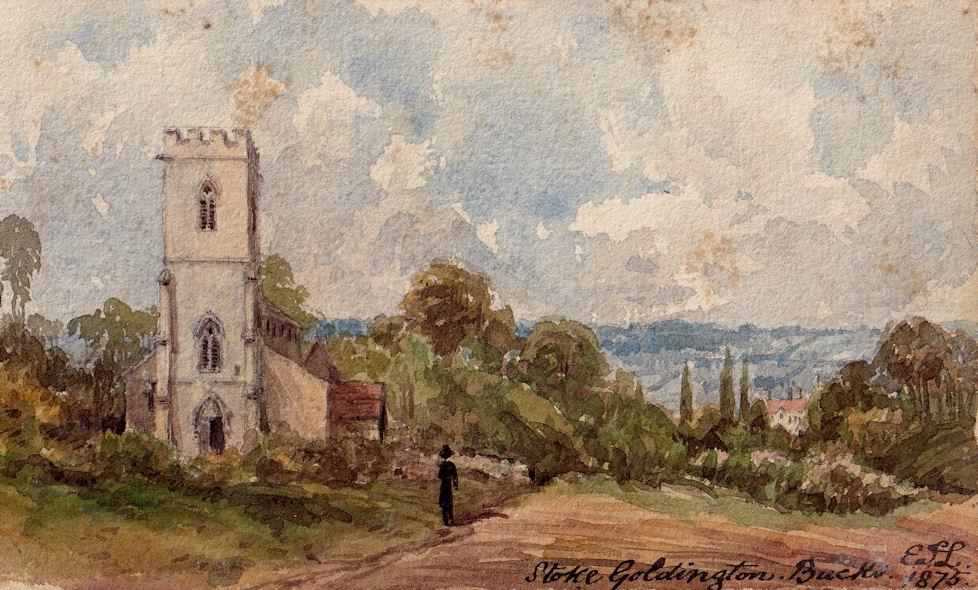
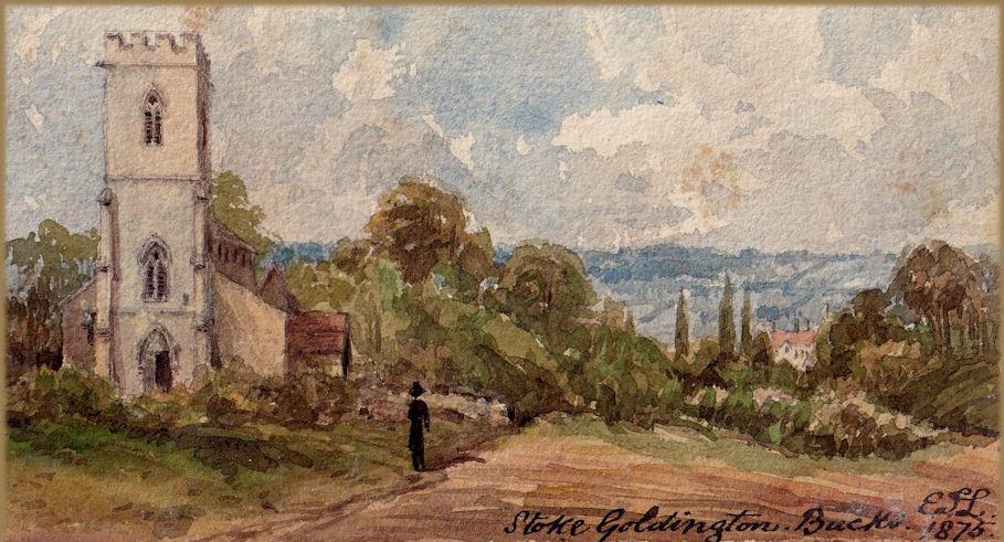
inscribed signed with monogram and dated " Stoke Goldington Buck E.T.L. / 1876"
Stoke Goldington is a village and civil parish in the Borough of Milton Keynes and ceremonial county of Buckinghamshire, England. It is located about four miles NNW of Newport Pagnell, on the B526, the old road to Northampton.
The village name 'Stoke' derives from the Old English 'stoc', which means 'place'. It came to be used in the context of either a religious or a secondary settlement, and is one of the most common place name elements in England (see Stoke (disambiguation)). In the Domesday Book of 1086 the village was recorded as Stoche. The affix 'Goldington' came later and refers to "Peter of Goldington" (from Goldington in Bedfordshire) who was a significant tenant in the village in the medieval period.
Parish Church. Rubblestone with lead roofs on nave and aisles,tile roof on chancel. Nave early C12, with C16 clerestory windows.
South aisle circa 1240 and north aisle circa 1250. Chancel rebuilt and south chapel added circa 1330, also south porch. North aisle rebuilt circa 1400. West tower mid C15. In C16 north aisle shortened. Chancel arch Norman, as is north door. Early English nave arcade
of 3 bays. Tower of 2 stages with battlemented parapet. Tub front C12 on moulded base. Pulpit early C18. Royal arms of William IV.
Wall monument to Thomas Hodgkins, 1720, his wife and daughter has an inscription panel with narrow sienna marble surround,
moulded base and cherub urn; above is a cornice and broken pediment with central urn. East window stained glass by Kempe 1902.
RCHM II 280 Monument l.
The village is situated in a hollow and is built on an exposure of Upper Lias clay. This is unusual, the early people tried to avoid building on clay. It could be that the village was originally centred round the church, evidence does point to this fact. Here the village would be on higher ground and built on limestone affording better drainage and so less damp. It seems that over the ages the village has crept down into the hollow where it is possibly more sheltered, the reason for this may be due to periods of very severe winters experienced during the late 17th century and the early 19th century.
To the east lies a large deposit of river gravels which was exploited commercially. These were formed by an overflow channel from the Nene system at a time when the Great Ouse and the Nene were very much larger than they are today. To the north is Salcey Forest growing on a thick deposit of Boulder Clay, this clay is up to 90 feet thick. To the south and west it is mainly limestone with little if any covering of Boulder Clay.
From Stoke Goldington to Weston Underwood the high ground near the gravel workings is the site of a Romano British settlement. Deer antlers have been found that had been cut by these people, the road goes through the settlement, there is more to discover on the south side of the road. There are deep V shaped ditches, and in one some years ago the remains of an infant burial were discovered. The date has been fixed at 2nd century A.D. To the south east is the wide valley of the Great Ouse river, with Ravenstone Mill. Around this area aerial photography shows evidence of many ring ditches. One of these ditches was excavated in the area of the gravel pits, little was found.
The village was originally an Anglo Saxon settlement and was lucky to avoid being invaded by the Danes during the Viking invasions. The insurgents halted their advance at what is now the Buckinghamshire County border right on the edge of Salcey Forest, less than one mile from the village.
Following the Norman invasion in the property share out by the conquerors, the village and the surrounding area were given to Sir Peter De Goldington who decided to change the name from Stoches to Stoke Goldington. This was how it was known in the Domesday Book.
In the Norman survey the village was called STOCKES. At one time the village was nearer the church, evidence of which is proved by foundations of buildings found when excavations have been made. Also near the church are the remnants of the old Manor House with traces of what might have been a moat and fish ponds in Home Close.
The land close by is known as Stoke Park it is not known to whom the park belonged. It has been reported that many oyster shells have been found in the field nearby.
In 1265 Isabel De Goldington sole heiress of Sir Peter’s grandson married Sir William De Nowers of ‘Gaithurst’ and so the control of the two villages was joined and the ownership remained at Gayhurst for the next six hundred and fifty years.
In 1273 Peter de Goldington who held lands in Northamptonshire, Goldington and Ravensthorpe died without a male heir, his three daughters Diomysia, Matilda and Isobella married and the partition of the land was made between them. The estate passed through many hands and in 1521 Michael Nevill died, he was in possession of both Gayhurst and Stoke Goldington manors and advowson. Queen Elizabeth I passed it to Sir Henry Berkely for 21 years at a rent of £73.13s 8d.
In the Norman Survey the lands in the Bonestou Hundred of William Peverell were described as a manor held under him by Drogo. The manor had been held by the Countess Gueth. The manor passed to the barentines who granted it in 1345 to the Priory of Ravenstone by Drugo Barentine.
The estate was later purchased by Dr Bushby’s trustees and with Willen added to the doctor’s charity. This was contested by lay patrons and finally it was given to Cardinal Wolsey by Henry VIII.
In 1581 Queen Elizabeth 1st gave the estates of Gayhurst and Stoke Goldington to Sir Francis Drake, partly as a reward for the treasures that he had collected for her on his round the world voyages. Drake who needed cash to finance further voyages sold the villages within a couple of days of being presented with them.
In 1596 Everard Digby married Mary Mulso and so started the ill fated Digby dynasty at Gayhurst. Everard was one of the principal plotters in the Gunpowder Plot, in fact much of the planning took place in the yew tree lined walk at the back of the house, still known as “Digby’s walk”.
As any school boy knows the plot failed on November 5 1605. Digby and the other plotters were hunted down. Everard was caught by the Sheriff of Warwickshire and following the subsequent trial was hung drawn and quartered.
His property was confiscated, but his wife had prudently put the estate into a trustee-ship in a pre-nuptual aggreement an so by 1608 Lady Mary, his widdow had obtained its restitution to the family. An extraordinarily achievement considering the enormity of her husband’s crime.
Later it was in the possession of Everard Digby and 1736 George Wright the Lord of the Manor obtained a licence from the Bishop of Lincoln for the annexation and consolidation of the church of Stoke Goldington and Gayhurst, since then both livings have been ministered by the one incumbent.
In 1771 an act of parliament for dividing the open and common lands in Stoke Goldington and compensation was made to the Rev. Robert Dowbiggin the rector in lieu of compensation of his glebe land.
Thomas Scott the Commentator who was minister here described the village in 1773:- “The country is pleasant, the village large and populous, but the people poor, ignorant and idle. The highest wage of the labourer in harvest time is only 1/6 per day, without meat. Half of the inhabitants have little more knowledge, save the art of lace making, than they were born with. There are no schools for the poor and they have no means of instruction but at church, where the greater part never come. Those that have any religion, are almost all Methodists, and fanatics of one sort or another. Taking the whole country, I think it remarkably poor and ignorant”.
The village became the property of the Wrighte family who held it for three generations (one hundred and twenty six years in total) but in 1837 ownership passed to Ann Wyndham who married Lord Macdonald of Slate.
The church dedicated to St. Peter stands on a hill north west of the village. It is an old building, the piers and arches of the nave Early English, the lower part of the tower is Decorated and the upper Perpendicular architecture. There are five bells. The first inscribed Thomas Hodgkin, Will Waring Churchwardens. Henry Penn made me 1707, there are three coins inserted which are illegible. The 2nd, 3rd, 4th and 5th God Save KYNG Charles 1625. It is said one of the bells came from the demolished church at Filgrave, possibly a treble, which has been recast. The other four bells were cast at Buckingham by Robert Atton.
On the west front of the tower is a recessed pointed arch door. Each side of the nave are pointed arches on large circular pillars with three clerestory windows on the south side. The chancel arch is semi-circular. There is a piscina in the side chapel, the font is Norman.
To the west of the church is the area called Gorefields there was a moat which once encircled a monastery the stronghold of Stoke. There is a legend that an underground passage exists from this area to Gayhurst House.
Eakley Lanes was thought to have been a separate parish, there was a chapel there and services were held once a month. There were two manors one called Wolf’s Fields and the other Eakley Lanes and was for many years owned by the Lane family.
The Rectory was of local limestone with a tiled roof, the old rectory was pulled down and was subsequently rebuilt by the Rev. Charles Jerdein M.A. who was the first resident rector for nearly a century. At one time the village boasted the largest walnut tree in England, said to have been in the field near to the rectory. This was felled in 1941. The school stands on the village green and in 1885 J.W.Carlile erected the reading room. The Congregational Chapel was built in 1819.
In 1830 the parish had seven coaching inns, starting at The Bull’s Head there were The Monarch, The Black Dog, The White Hart and The George and Dragon all at Eakley. Nearer to home the Coach and Horses and The George Inn. The North-South mail, Liverpool, Manchester, Birmingham and London met up with the East-West mail at Northampton. There were twenty six scheduled mail coaches in each direction travelling through the village each day and they all required horse changing and accomodation facilities.
By the early 1840’s most of this trade had disappeared with the development of the London (Euston) to Birmingham (New Street) railway line and the building of the Grand Union canal. The coaching inns gradualy became farmhouses. In the 1841 census there were shown to be two hundred and forty seven hand lacemakers in the village by the end of the century this figure had shrunk to forty two following the invention of machine made lace.
The population of the village mirrored these commercial developments. In 1801 there were 636 living there, this rose to 855 in 1841 and was back to 576 in 1901. In 1842 the Carrington family took a twenty one year lease on the Gayhurst Estate which included the village but it was eventually sold to James William Carlile in 1882. The Carlile family (James and his son Walter) lived at Gayhurst House until Walter’s death in 1950.
The Carliles were very generous individuals who took the responsibility of owning the village very seriously. In 1882 James commissioned the building of the Stoke Goldington Water Works he had underground reservoirs built near St Peter’s Church and on the hill at the back of Mount Pleasant and had running water piped into the village. The system is still in existence and there are still half a dozen families in the village who can still get ‘Stoke Water’. A major refurbishment of St Peter’s Parish Church, the building of the Village Reading Rooms, the gift of both the Village Green and Recreation Ground were other acts of philanthropy by the Carlile’s. Sir Walter Carlile became Member of Parliament for North Buckinghamshire and was the first MP to drive to the House of Commons in a motor car.