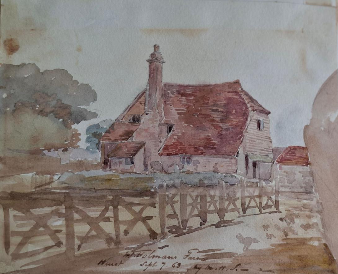
inscribed and dated " Mr Holman's Farm / Hurst / sept 7 63
Hurstpierpoint is a village in the Mid Sussex district, in the county of West Sussex, England, 4 miles (6.4 km) southwest of Burgess Hill, and 1.5 miles (2.4 km) west of Hassocks railway station. It sits in the civil parish of Hurstpierpoint and Sayers Common which has an area of 2029.88 ha and a population of 7,112.
The village was once chiefly one long street running east and west and most of the buildings in it are of the 18th century or later. The late 20th Century and early 21st Century saw Hurstpierpoint expanding greatly with new homes built north, east and west of the village.
Hurstpierpoint hosts the Hurst Festival which takes place every summer and has an active Scouts and Guides Groups.
Established in 1962, the Hurstpierpoint Society is a village organization with over 1,300 members, dedicated to enhancing and safeguarding the village surroundings and examining local planning proposals.
Geography
The village is built on a sandstone ridge,[3] 145 feet (44 m) above sea level, running east and west across the parish, on the road from Lewes to Albourne. This is crossed in the centre of the village by Cuckfield Road which goes north to Cuckfield. Hurstpierpoint is located close to the A23.
History

The Hurstpierpoint manor held all the land in a giant parish. Before the Norman Conquest it was owned by Earl Godwin. In the Domesday Book of 1086, the settlement was named as Herst in the ancient hundred of Buttinghill.[4][5] After the Conquest, it was held by the de Pierpoints for many centuries.
There were twin Parks at Hurstpierpoint through the later Middle Ages, Little Park north of the Greensand ridge and Danny, or Great Park (TQ 285 152) to its south. Danny Park was made by enclosing existing woodland in the early 13th century. It remained a special place right up until the 1970s, particularly for its many ancient elms, which formed an avenue northwards from the house.
The name "Hurstpierpoint" derives from two sources. The first source is 'Hurst' (also spelled 'hyrst', 'herst' or 'hirst'), the Saxon name for a wooded hill. The hill woodland is likely to have been on the shadier, northern side of the greensand ridge, for the sunny south side is partially on the Lower Greensand which is an area that early farmers would have settled for the fertile ground, for example at Wanbarrow, Washbrooks, Tott Farm and Bedlam Street. The second source is de Pierpoint family who were early owners of the property. Throughout the centuries there have been several variants on the Hurstpierpoint name e.g. Herst (11th century); Herstperpunt (14th century); Perpondesherst (15th century).
In 1971 the civil parish had a population of 5355. On 1 April 2000 the parish was abolished to form "Hurstpierpoint and Sayers Common", part also went to Albourne and Burgess Hill.
Notable buildings and areas

The greensand ridge from Hurstpierpoint to Ditchling, is tracked by both the modern B2116 road, and the Roman Greensand Way whose camber is still visible at Randolphs Farm (TQ 278 158) and at Danny's Sandy Field (TQ 288 156).[6]
To the south are the South Downs and Wolstonbury Hill. Between the village and the Hill is Danny Park and the Danny Woods. To the north of Hurstpierpoint is a waterland geography which is centred around the Herrings Stream.
There are five churches in the village which are St George's (not in use), Hurstpierpoint Methodist Church, Hurstpierpoint Good News Church and St Luke's Roman Catholic Church, which was closed in December 2019 and the Holy Trinity parish church.
Holy Trinity

The parish church was a Norman church, but was largely rebuilt from the designs of Sir Charles Barry in 1843–5, who was famous for designing the Houses of Parliament. In 1854, the north chapel was added, in 1874 the south chapel and the north transept has been fitted up as a chapel in memory of those who died in the War of 1914–18. A number of funeral monuments and fittings were preserved from the old church. The font is probably from the 13th century, but the heavy round bowl has been reworked and painted. In the east window of the south chapel are set fifteen medallions of German or Flemish glass of the 16th and 17th centuries. In the south chapel is a much weathered recumbent effigy from 1260 of a cross-legged knight in chain armour, and at the west end of the north aisle is a much mutilated effigy of a knight from 1340. In the churchyard by the west wall are five tapering coffin lids from the 12th or 13th century, with hollow chamfered edges. One shows faint traces of a raised cross. The pavement outside the west doorway has about 150 inlaid slip tiles from the late 13th or early 14th century, which are suffering from wear.
Danny House
Main article: Danny House

Danny House (TQ 284 148) is an extravagant Elizabethan building. It is built of warm brick with a sunny Queen Anne south face and an E-faced eastern front with mullioned stone windows rising to the full height of the building and flooding the Great Hall behind in morning light.
Elms once lined the drive to the House, but are now gone as a result of Dutch elm disease.
Danny Lake and Pondtail Wood (TQ 288 153) that embraces it have been restored in recent times. The wood has bluebells, anemones and primroses.
Richard Suter (1797–1883).
Richard Suter was born in Greenwich, Kent on 30th March 1798, to William Suter and his wife Sarah Knights. On 7th January 1825 he married Anne Ruth Burn.
English architect. As Surveyor to The Fishmongers' Company he designed the severe Presbyterian churches for Ballykelly (1825–7) and Banagher (1825) on the Company's Estate in County Londonderry, drawings of which were exhibited at the Royal Academy in 1827. He was also responsible for the Model Farm (1823–4), the Lancasterian Schools (1828–30), the Company Agent's House (1830–2—now a hotel, much altered), a range of houses on the south side of the main road (1823–4), the lodge in the Presbyterian churchyard (1828), and the Dispensary (1829), all at Ballykelly, and all Classical. As Surveyor to Trinity House Corporation, he designed houses that were erected by Thomas Cubitt in 1821–3 on a site adjoining Trinity House. For The Fishmongers' Company he designed St Peter's Almshouses, Wandsworth, London (1849–51), and The Old School-House, Gresham's School, Holt, Norfolk(1859), in an Elizabethan style.
On the 1841 Census Richard, an architect and lawyer, can be found living in London with his wife Ann (listed as Ruth) and their two children, Richard George and Andrew Burn. Living with them is Edward D Suter. 1851 finds the family living in Tottenham Court in London, by this time Andrew had left the home, but I am unable to trace him on the 1851 Census. In 1860 Andrew marries Amelia Damaris Harrison. Both Richard George and Andrew were to become ordained ministers, with Andrew later becoming a Bishop and emigrating to New Zealand. Sadly in 1854 Anne Ruth was to pass away. In 1861, widowed Richard, Justice of the Peace for Maidenhead, is living at Castle Hill, Maidenhead, Berkshire. In 1862 he married Elizabeth Anne Pocock. In 1871 and 1881 Richard and Elizabeth are still living in Castle Hill. Richard was to pass away on 1st March1883.
Richard Suter & Annesley Voysey, architects, had their office at number 35 Fenchurch Street, but they did not have it all to themselves as they shared the premises with W.C. Franks, a tea broker, who will get a separate post some other time. The earliest mention I found of Richard Suter in Fenchurch Street is in 1832 when he is listed at that address in a list of contributing members of the Society for the Propagation of the Gospel in Foreign Parts. It says that he had been a member since 1829, but that does not mean he was already at 35 Fenchurch Street in that year.(1) In fact, that seems unlikely as the Sun Fire Office records give Messrs. Short and Co., merchants, as paying the insurance premium on the premises in May 1830. The Directory of British Architects 1834-1914 give the year 1827, but I do not know on what evidence. When Suter and Voysey became partners is also uncertain, but they had known each other since at least 1825 as Suter is named as one of the executors of Voysey’s will which was dated 22 July, 1825. The address given for Suter in the will is Suffolk Street, Southwark. Voysey then lives at Conway Street, Fitzroy Square.