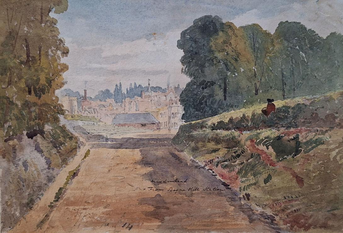
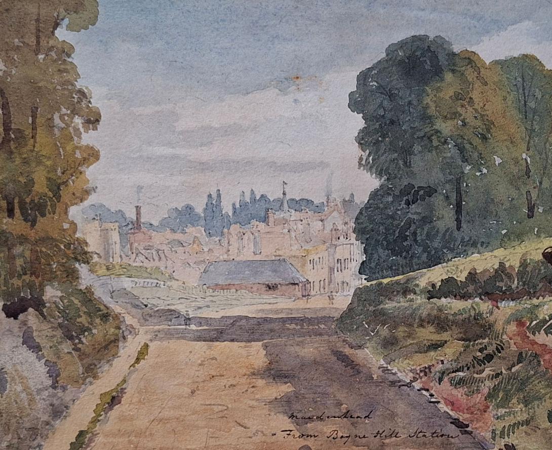
Maidenhead from Boyne Hill Station 1867
In 1867, Boyne Hill Station served as the initial Wycombe Railway stop for Maidenhead, connecting to London Paddington via the Great Western Railway, but it was a temporary solution, closing in 1871 when Maidenhead Junction opened on the main line, offering better connections and leading to the eventual development of the current Maidenhead railway station from that junction site.
Maidenhead Boyne Hill Railway Station (Disused) This was the original station for the Wycombe Railway, serving as the town's western rail link before the current Maidenhead station was consolidated. Opened August 1, 1854; closed November 1, 1871.Situated on Castle Hill (A4 Bath Road).
Visible Remains: Today, the station is known for its bricked-up arches visible in the southern parapet of the A4 bridge. These arches once served as entrances to the platforms below.
Boyn Hill Suburb (Maidenhead) Boyn Hill is a residential area and ward located west of the town centre, between the A4 and the main railway line.
Church of All Saints: A Grade I listed Victorian Gothic church designed by G.E. Street. Its 150-foot spire is the highest point in Maidenhead.
"Boyne Hill Vicarage, Maidenhead": A well-known oil painting (c. 1910) by Malcolm Drummond, a member of the Camden Town Group, depicting his childhood home. The original is held in the Tate collection.
Maidenhead Boyne Hill Station was opened on the 1st August 1854 as part of the Wycombe Railway and virtually unnoticed it still stands there today. As you climb up Castle Hill out of Maidenhead the A4 road passes over the line at a point where an elaborate brick structure looks a little too complicated to be just a simple bridge. Two bricked up arches give the game away. These were the original entrances to Maidenhead Boyne Hill station’s platforms below. It’s tempting to wonder what is behind these walls _ are there still steps down and was everything removed before they were sealed like some kind of tomb? The answer was discovered during a site inspection in 2015. “Basically there are a series of vaults/chambers adjacent to the A4, below the footway and across the railway line. There are 9 in total, with the two end ones being the arches which were blocked up and are visible from the roadside, one of which has the door inset into. Within these two there are also small openings on the railway side of the structure , other than these two the other 7 are completely sealed. At some point in the past minor repairs have been carried out which included installing supporting bars and creating holes between the vaults to allow access to them all” (with thanks to James Church and Vince Blissett for this information). The station was originally simply called Maidenhead (Wycombe Branch) and acquired its Boyne Hill suffix at a later date. Its period in use was short too, it had closed by 1871 less than 20 years after it had opened. Perhaps the walk up the hill to the station from the town did not help its survival but ultimately it was the new Maidenhead Station located on the main line from Paddington that sealed its fate. Opening on the same day as Boyne Hill closed it has remained Maidenhead’s station to this day.
Maidenhead is a market town in the Royal Borough of Windsor and Maidenhead in the county of Berkshire, England. It lies on the southwestern bank of the River Thames, which at this point forms the border with Buckinghamshire. In the 2021 Census, the Maidenhead built-up area had a population of 67,375. The town is 27 miles (43 km) west of Charing Cross, London and 13 miles (21 km) east-northeast of Reading.
The antiquary John Leland claimed that the area around Maidenhead's present town centre was a small Roman settlement called Alaunodunum. He stated that it had all but disappeared by the end of the Roman occupation. Although his source is unknown, there is documented and physical evidence of Roman settlement in the town. There are two well known villa sites in the town, one being in the suburb of Cox Green, and the other just west of the town centre on Castle Hill. This villa sat on the route of the Camlet Way which was a Roman road linking Silchester (Calleva Atrebatum) and Colchester (Camulodunum) via St Albans (Verulamium) and passes through the present town centre. Remnants of the road have been unearthed at various locations nearby, but its exact route is unclear.
Maidenhead's name stems from the riverside area where the first "New wharf" or "Maiden Hythe" was built, as early as Saxon times. In the year 870, an army of Danes invaded the kingdom of Wessex. They disembarked from their longboats by the wharf and ferry crossing at Maidenhead and fought their way overland to Reading where they set up camp and made it their regional power base. The area of the present town centre was originally a small Anglo-Saxon town known as "South Ellington". The town would have likely developed on the Camlet Way on the site of Alaunodunum as the Bath Road was not re-routed until the 13th century. Maidenhead is recorded in the Domesday Book as the settlement of Ellington in the hundred of Beynhurst.
A wooden bridge was erected across the river in about 1280 to replace the ferry in South Ellington. The Great West Road to Reading, Gloucester and Bristol was diverted over the new bridge. Previously, it had kept to the north bank and crossed the Thames by ford at Cookham, and the medieval town, later to become Maidenhead grew up on the site of Alaunodunum and South Ellington, between the new bridge and the bottom of Castle Hill. Within a few years a new wharf was constructed next to the bridge to replace the old Saxon wharf which needed replacing. At this time, the South Ellington name was dropped with the town becoming known as Maidenhythe. The earliest record of this name change is in the Bray Court manorial rolls of 1296.
The new bridge and wharf led to the growth of medieval Maidenhead as a river port and market town. The present town was developed as a linear settlement in the 13th century along the newly diverted road with hostelries, a guildhall and a chapel dedicated to St Mary Magdalene was built in the middle of the road. The market was held outside the old guildhall which was set back from the High Street to form the market square. Maidenhead also became the first stopping point for coaches travelling from London to Gloucester and Bath and the town became populated with numerous inns. By the mid 18th century, Maidenhead was one of the busiest coaching towns in England with over ninety coaches a day passing through the town. The late 18th-century Bear Hotel on the High Street is the best of the town's old coaching inns surviving to this day.
King Charles I met his children for the last time before his execution in 1649 at the Greyhound Inn on the High Street, the site of which is now a branch of the NatWest Bank. A plaque commemorates their meeting. When the Great Western Railway came to the town, it began to expand. Muddy roads were replaced and public services were installed. The High Street began to change again, and substantial Victorian red brick architecture began to appear throughout the town. Maidenhead Citadel Corps of the Salvation Army was first opened in the town in the mid-1880s. Maidenhead Citadel Band was soon founded in 1886 by Bandmaster William Thomas, who later became mayor of the town. By Edwardian times, nearby Boulter's Lock became a favoured resort, especially on Ascot Sunday, and Skindles Hotel developed a reputation for illicit liaisons.
Richard Suter was born in Greenwich, Kent on 30th March 1798, to William Suter and his wife Sarah Knights. On 7th January 1825 he married Anne Ruth Burn.
English architect. As Surveyor to The Fishmongers' Company he designed the severe Presbyterian churches for Ballykelly (1825–7) and Banagher (1825) on the Company's Estate in County Londonderry, drawings of which were exhibited at the Royal Academy in 1827. He was also responsible for the Model Farm (1823–4), the Lancasterian Schools (1828–30), the Company Agent's House (1830–2—now a hotel, much altered), a range of houses on the south side of the main road (1823–4), the lodge in the Presbyterian churchyard (1828), and the Dispensary (1829), all at Ballykelly, and all Classical. As Surveyor to Trinity House Corporation, he designed houses that were erected by Thomas Cubitt in 1821–3 on a site adjoining Trinity House. For The Fishmongers' Company he designed St Peter's Almshouses, Wandsworth, London (1849–51), and The Old School-House, Gresham's School, Holt, Norfolk(1859), in an Elizabethan style.
On the 1841 Census Richard, an architect and lawyer, can be found living in London with his wife Ann (listed as Ruth) and their two children, Richard George and Andrew Burn. Living with them is Edward D Suter. 1851 finds the family living in Tottenham Court in London, by this time Andrew had left the home, but I am unable to trace him on the 1851 Census. In 1860 Andrew marries Amelia Damaris Harrison. Both Richard George and Andrew were to become ordained ministers, with Andrew later becoming a Bishop and emigrating to New Zealand. Sadly in 1854 Anne Ruth was to pass away. In 1861, widowed Richard, Justice of the Peace for Maidenhead, is living at Castle Hill, Maidenhead, Berkshire. In 1862 he married Elizabeth Anne Pocock. In 1871 and 1881 Richard and Elizabeth are still living in Castle Hill. Richard was to pass away on 1st March1883.
Richard Suter & Annesley Voysey, architects, had their office at number 35 Fenchurch Street, but they did not have it all to themselves as they shared the premises with W.C. Franks, a tea broker, who will get a separate post some other time. The earliest mention I found of Richard Suter in Fenchurch Street is in 1832 when he is listed at that address in a list of contributing members of the Society for the Propagation of the Gospel in Foreign Parts. It says that he had been a member since 1829, but that does not mean he was already at 35 Fenchurch Street in that year.(1) In fact, that seems unlikely as the Sun Fire Office records give Messrs. Short and Co., merchants, as paying the insurance premium on the premises in May 1830. The Directory of British Architects 1834-1914 give the year 1827, but I do not know on what evidence. When Suter and Voysey became partners is also uncertain, but they had known each other since at least 1825 as Suter is named as one of the executors of Voysey’s will which was dated 22 July, 1825. The address given for Suter in the will is Suffolk Street, Southwark. Voysey then lives at Conway Street, Fitzroy Square.