page from an album inscribed in the frontispage "F W Staines 3 Uplands St Leonards on Sea"
Amelia Jackson, Nee Staines (1842 – 1925) and thence by descent
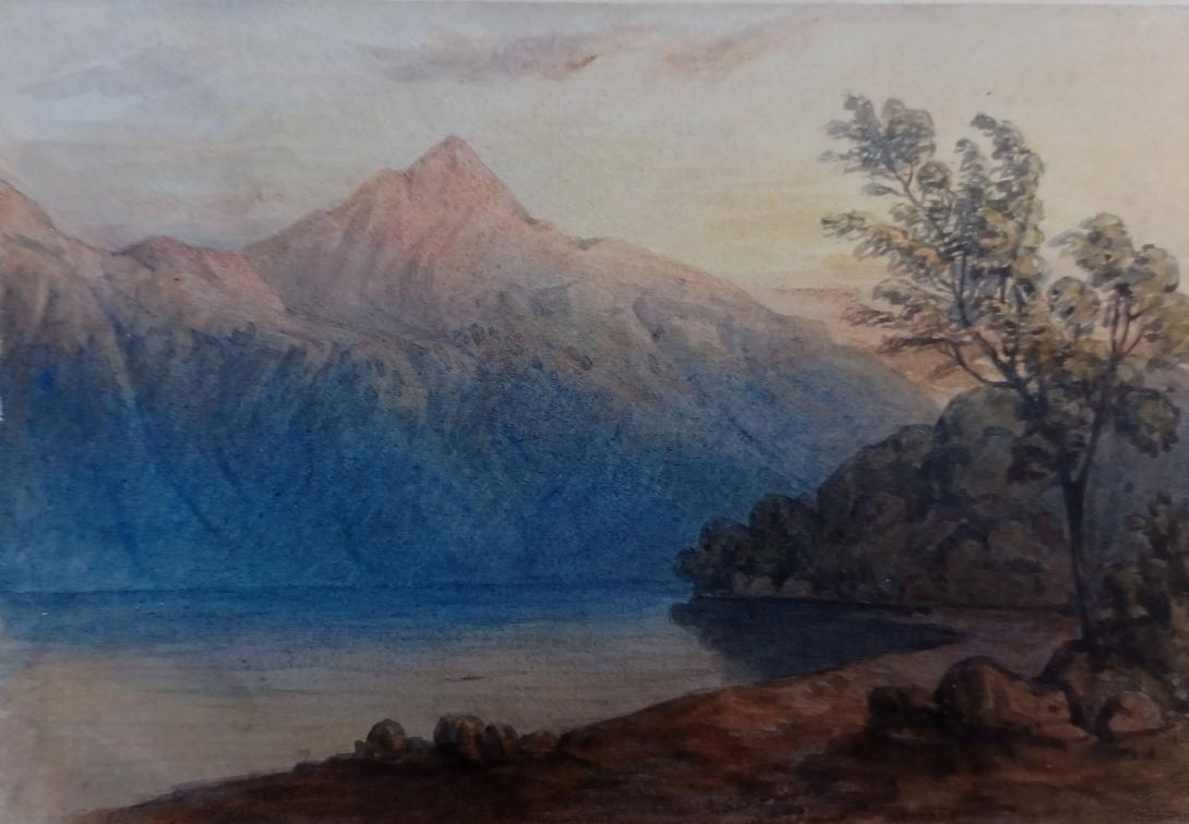
Ben Lomond (Scottish Gaelic: Beinn Laomainn, 'Beacon Mountain'), 974 metres (3,196 ft), is a mountain in the Scottish Highlands. Situated on the eastern shore of Loch Lomond, it is the most southerly of the Munros. Ben Lomond lies within the Ben Lomond National Memorial Park and the Loch Lomond and The Trossachs National Park, property of the National Trust for Scotland.
Its accessibility from Glasgow and elsewhere in central Scotland, together with the relative ease of ascent from Rowardennan, makes it one of the most popular of all the Munros. On a clear day, it is visible from the higher grounds of Glasgow and across Strathclyde. Ben Lomond’s summit can also be seen from Ben Nevis, the highest peak in Britain, over 40 miles (64 km) away. The West Highland Way runs along the western base of the mountain, by the loch.
Ben Lomond's popularity in Scotland has resulted in several namesakes in the former British colonies of Australia, Canada, New Zealand, Jamaica, Trinidad and Tobago, and the United States – see this list. The mountain is mentioned directly in the popular folk song "The Bonnie Banks o' Loch Lomond".
The name Ben Lomond is generally agreed to mean "beacon mountain" or "beacon hill". Lomond is of Brittonic origin and derived from the element lumon meaning "a beacon" (Welsh llumon). This element, preserved in Scots as lum meaning "chimney", is found in other hill-names such as the Lomond Hills in Fife and Pumlumon in Wales. Like these hills, Ben Lomond is likely to have been perceived as a central point, probably the meeting-point of several territorial boundaries, where a signal beacon may have been frequently lit.

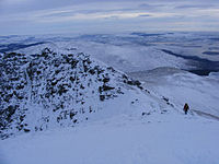
Ben Lomond has a craggy summit which appears conical when viewed from the nearby Arrochar Alps range. The mountain comprises two parallel south-southeasterly ridges: the Sròn Aonaich ridge to the east and the Ptarmigan ridge to the west. North of the summit these ridges come together and lead to a 456-metre (1,496 ft) col with Cruin a' Bheinn, a Graham. The summit is grassy and rocky and is marked by a triangulation pillar.
Ben Lomond's geology is dominated by granite, mica schist, diorite, porphyry and quartzite. Ben Lomond lies on the Scottish watershed, the drainage divide which separates river systems that flow to the east from those that flow to the west.
The usual route up Ben Lomond is via the 'tourist path', a wide, eroded and easy path which is roughly paved in steeper sections.This track was created owing to the mountain's status as one of the most popular in Scotland and climbs the gentle Sròn Aonaich ridge, before ascending a steeper section to the rocky summit ridge.
An alternative route follows the Ptarmigan ridge to the summit along a steeper and rockier path.The Ptarmigan path is the second most popular route, followed by a third route which approaches from Gleann Dubh.
Despite the comparative ease of the tourist route, Ben Lomond can present a significant challenge to inexperienced walkers, especially in poor weather conditions. A dedicated Lomond Mountain Rescue Team has existed since 1967 to assist walkers and climbers on Ben Lomond and other surrounding peaks.
-
A walker descending by the tourist route, seen from the summit in January 2010.
-

The summit of Ben Lomond seen from high on the Ptarmigan ridge in January 2010.


The higher regions of the mountain support an alpine tundra ecozone, hosting bird species including peregrine falcon, merlins, rock ptarmigan, red grouse and golden eagles. A study by the British Trust for Ornithology found that Ben Lomond may host the most southerly breeding ptarmigan population in Scotland, following the decline of populations on Goatfell and the Arran mountains, possibly as a result of climate change.
In addition to natural wildlife, the mountain area supports sheep farming. The National Trust for Scotland is tasked with maintaining a land management programme which sustains a balance of natural habitat conservation and the availability of land for grazing.
Since 1995, the area around Ben Lomond, including the mountain summit, has been designated as a war memorial, called the Ben Lomond National Memorial Park. The park is dedicated to those who gave their lives in the First and Second World Wars and was created out of the former Rowardennan Estate with the support of the National Heritage Memorial Fund.
The Memorial Park was officially opened on Armistice Day in 1997 by the Rt Hon Donald Dewar, then Secretary of State for Scotland and later the first First Minister of Scotland. At the opening ceremony he unveiled a granite sculpture by Doug Cocker, a Scottish artist who had won a competition organised by the Scottish Sculpture Trust to design a permanent monument for the park.
At the time of its creation, management of the Memorial Park was entrusted to the NTS, Forestry Commission and the now defunct Scottish Office.
In 2002, the Scottish Parliament created the Loch Lomond and the Trossachs National Park, the first national park in Scotland. The national park includes the whole of Ben Lomond National Memorial Park.
Loch Lomond is a freshwater Scottish loch which crosses the Highland Boundary Fault, often considered the boundary between the lowlands of Central Scotland and the Highlands. Traditionally forming part of the boundary between the counties of Stirlingshire and Dunbartonshire, Loch Lomond is split between the council areas of Stirling, Argyll and Bute and West Dunbartonshire. Its southern shores are about 23 kilometres (14 mi) northwest of the centre of Glasgow, Scotland's largest city. The Loch forms part of the Loch Lomond and The Trossachs National Park which was established in 2002.
Loch Lomond is 36.4 kilometres (22.6 mi) long and between 1 and 8 kilometres (0.62–4.97 mi) wide, with a surface area of 71 km2 (27.5 sq mi). It is the largest lake in Great Britain by surface area; in the United Kingdom, it is surpassed only by Lough Neagh and Lough Erne in Northern Ireland. In the British Isles as a whole there are several larger loughs in the Republic of Ireland. The loch has a maximum depth of about 190 metres (620 ft) in the deeper northern portion, although the southern part of the loch rarely exceeds 30 metres (98 ft) in depth. The total volume of Loch Lomond is 2.6 km3 (0.62 cu mi), making it the second largest lake in Great Britain, after Loch Ness, by water volume.
The loch contains many islands, including Inchmurrin, the largest fresh-water island in the British Isles. Loch Lomond is a popular leisure destination and is featured in the song "The Bonnie Banks o' Loch Lomond". The loch is surrounded by hills, including Ben Lomond on the eastern shore, which is 974 metres (3,196 ft) in height and the most southerly of the Scottish Munro peaks. A 2005 poll of Radio Times readers voted Loch Lomond as the sixth greatest natural wonder in Britain.
The depression in which Loch Lomond lies was carved out by glaciers during the final stages of the last ice age, during a return to glacial conditions known as the Loch Lomond Readvance between 20,000 and 10,000 years ago. The loch lies on the Highland Boundary Fault, and the difference between the Highland and Lowland geology is reflected in the shape and character of the loch: in the north the glaciers dug a deep channel in the Highland schist, removing up to 600 m of bedrock to create a narrow, fjord-like finger lake. Further south the glaciers were able to spread across the softer Lowland sandstone, leading to a wider body of water that is rarely more than 30 m deep. In the period following the Loch Lomond Readvance the sea level rose, and for several periods Loch Lomond was connected to the sea, with shorelines identified at 13, 12 and 9 metres above sea level (the current loch lies at 8 m above sea level).
The change in rock type can be clearly seen at points around the loch, as it runs across the islands of Inchmurrin, Creinch, Torrinch and Inchcailloch and over the ridge of Conic Hill. To the south lie green fields and cultivated land; to the north, mountains.
See also: List of freshwater islands in Scotland § Loch Lomond

The loch contains thirty or more other islands, depending on the water level. Several of them are large by the standards of British bodies of freshwater. Inchmurrin, for example, is the largest island in a body of freshwater in the British Isles. Many of the islands are the remains of harder rocks that withstood the passing of the glaciers; however, as in Loch Tay, several of the islands appear to be crannogs, artificial islands built in prehistoric periods.
English travel writer, H.V. Morton wrote:
What a large part of Loch Lomond's beauty is due to its islands, those beautiful green tangled islands, that lie like jewels upon its surface.
Writing 150 years earlier than Morton, Samuel Johnson had however been less impressed by Loch Lomond's islands, writing:
But as it is, the islets, which court the gazer at a distance, disgust him at his approach, when he finds, instead of soft lawns and shady thickets, nothing more than uncultivated ruggedness.
— Johnson
The Scottish dock (Rumex aquaticus), sometimes called the Loch Lomond dock, is in Britain unique to the shores of Loch Lomond, being found mostly on around Balmaha on the western shore of the loch. It was first discovered growing there in 1936 (else it grows eastwards through Europe and Asia all the way to Japan).
Powan are one of the commonest fish species in the loch, which has more species of fish than any other loch in Scotland, including lamprey, lampern, brook trout, perch, loach, common roach and flounder. The river lamprey of Loch Lomond display an unusual behavioural trait not seen elsewhere in Britain: unlike other populations, in which young hatch in rivers before migrating to the sea, the river lamprey here remain in freshwater all their lives, hatching in the Endrick Water and migrating into the loch as adults.
The surrounding hills are home to species such as black grouse, ptarmigan, golden eagles, pine martens, red deer and mountain hares. Many species of wading birds and water vole inhabit the loch shore. During the winter months large numbers of geese migrate to Loch Lomond, including over 1% of the entire global population of Greenland white-fronted geese (around 200 individuals), and up to 3,000 greylag geese.
In January 2023 RSPB Scotland released a family of beavers into the southeastern area of the loch under licence from NatureScot. The beaver family, consisting of an adult pair and their five offspring, were translocated from a site in Tayside, where beaver activity was having a negative impact that could not be mitigated.
One of the loch's islands, Inchconnachan, is home to a colony of red-necked wallabies.
As well as forming part of the Loch Lomond and the Trossachs National Park, Loch Lomond holds multiple other conservation designations. 428 ha of land in the southeast, including five of the islands, is designated as national nature reserve: the Loch Lomond National Nature Reserve. Seven islands and much of the shoreline form a Special Area of Conservation (SAC), the Loch Lomond Woods. This designation overlaps partially with the national nature reserve, and is protected due to the presence of Atlantic oak woodlands and a population of otters. Four islands and a section of the shoreline are designated as a Special Protection Area due to their importance for breeding capercaillie and visiting Greenland white-fronted geese: this designation overlaps partially with both the national nature reserve and the SAC. Loch Lomond is also a designated Ramsar site, again for the presence of Greenland white-fronted geese.
The loch and its surrounding are designated as a national scenic area, one of forty such areas in Scotland, which have been defined so as to identify areas of exceptional scenery and to ensure its protection from inappropriate development.
People first arrived in the Loch Lomond area around 5000 years ago, during the neolithic era. They left traces of their presence at places around the loch, including Balmaha, Luss, and Inchlonaig. Crannogs, artificial islands used as dwellings for over five millennia, were built at points in the loch. The Romans had a fort within sight of the loch at Drumquhassle. The crannog known as "The Kitchen", located off the island of Clairinsh, may have later been used as a place for important meetings by Clan Buchanan whose clan seat had been on Clairinsh since 1225: this usage would be in line with other crannogs such as that at Finlaggan on Islay, used by Clan Donald.
During the Early Medieval period viking raiders sailed up Loch Long, hauled their longboats over at the narrow neck of land at Tarbet, and sacked several islands in the loch.
The area surrounding the loch later become part of the province of Lennox, which covered much of the area of the later county of Dunbartonshire.

Loch Lomond became a popular destination for travellers, such that when James Boswell and Samuel Johnson visited the islands of Loch Lomond on the return from their tour of the Western Isles in 1773, the area was already firmly enough established as a destination for Boswell to note that it would be unnecessary to attempt any description.

Loch Lomond is one of Scotland's premier boating and watersports venues, with visitors enjoying activities including kayaking, Canadian canoeing, paddle boarding, wake boarding, water skiing and wake surfing.[11] The national park authority has tried to achieve a balance between land-based tourists and loch users, with environmentally sensitive areas subject to a strictly enforced 11 km/h (5.9 kn; 6.8 mph) speed limit, but the rest of the loch open to speeds of up to 90 km/h (49 kn; 56 mph).
The Maid of the Loch was the last paddle steamer built in Britain. Built on the Clyde in 1953, she operated on Loch Lomond for 29 years. She is now being restored at Balloch pier by the Loch Lomond Steamship Company, a charitable organisation, supported by West Dunbartonshire Council.[38] Cruises also operate from Balloch, Tarbet, Inversnaid, Luss and Rowardennan.
Loch Lomond Rescue Boat provides 24-hour safety cover on the loch. The rescue boat is a volunteer organisation and a registered charity. The national park authority also have other boats on the loch such as The Brigadier. Police Scotland also operates on the loch using RIBs and jet skis and work in conjunction with the national park authority.
The loch has served as the venue for the Great Scottish Swim, which is held each year in August.
Fly and coarse fishing on Loch Lomond is regulated by the Loch Lomond Angling Improvement Association (LLAIA), who issue permits to members and visiting anglers. The association employ water bailiffs to monitor the actions of anglers on the loch and ensure angling is carried out in accordance with permit conditions.
Loch Lomond Golf Club is situated on the south-western shore. It has hosted many international events including the Scottish Open. Another golf club, "The Carrick" has opened on the banks of the Loch adjacent to the Loch Lomond Club.
The West Highland Way runs along the eastern bank of the loch, and Inveruglas on the western bank is the terminus of the Cowal Way. The West Loch Lomond Cycle Path runs from Arrochar and Tarbet railway station, at the upper end of the loch, to Balloch railway station, at the south end. The 17-mile-long (28 km) long cycle path runs along the west bank.
At the southern end of the loch near Balloch is a large visitor and shopping complex named Loch Lomond Shores.
As with all land and inland water in Scotland there is a right of responsible access to the loch and its shoreline for those wishing to participate in recreational pursuits such as walking, camping, swimming and canoeing. In 2017 the national park authority introduced byelaws restricting the right to camp along much of the shoreline of Loch Lomond, due to issues such as litter and anti-social behaviour that were blamed on irresponsible campers. Camping is now restricted to designated areas, and campers are required to purchase a permit to camp within these areas between March and October.The byelaws were opposed by groups such as Mountaineering Scotland and Ramblers Scotland, who argued that they would criminalise camping even where it was carried out responsibly, and that the national park authority already had sufficient powers to address irresponsible behaviour using existing laws.

The main arterial route along the loch is the A82 road which runs the length of its western shore, following the general route of the Old Military Road. The road runs along the shoreline in places, but generally keeps some distance to the west of the loch in the "lowland" section to the south. Much of the southern section of the road was widened to a high quality single carriageway standard over the 1980s, at an estimated cost of £24 million (£86 million as of 2021), while Luss itself is now bypassed to the west of the village along a single carriageway bypass constructed between 1990 and 1992. At Tarbet, the A83 branches west to Campbeltown while the A82 continues to the north end of the loch. This part of the road is currently of a lower standard than the sections further south. It is sandwiched between the shoreline of the loch and the mountains to the west, and it runs generally alongside the West Highland Line. The road narrows to less than 7.3 metres (24 ft) in places and causes significant problems for heavy goods vehicles (HGVs), which have to negotiate tight bends and the narrow carriageway width. At Pulpit rock, the road was single-track, with traffic flow controlled by traffic lights for over 30 years. The road was widened in 2015 as part of a £9 million improvement programme, including a new viaduct bringing the carriageway width to modern standards.
The A811 runs to the south of Loch Lomond between Balloch and Drymen, following the route of another military road at a distance of between 2 and 3 kilometres from the loch. From Drymen the B837 extends north, meeting the eastern shore of the loch at Balmaha where the road terminates. A minor road extends north as far as Rowardennan, a further 11 km away, however beyond this point no road continues along the eastern shore, although there is road access to Inversnaid via another minor road that comes in from Loch Katrine to the east via the northern shore of Loch Arklet. As Loch Arklet is over 100 m above Loch Lomond and less than 2 km to the east this road must descend steeply to reach Inversnaid.
The West Highland railway line joins the western shore of the loch just north of Arrochar and Tarbet railway station. There is a further station alongside the loch at Ardlui. This line was voted the top rail journey in the world by readers of independent travel magazine Wanderlust in 2009, ahead of the iconic Trans-Siberian line in Russia and the Cuzco to Machu Picchu line in Peru. The railway system also reaches the loch at Balloch railway station, which is the terminus of the North Clyde Line.
Several different operators offer ferry services on the loch.
Since 2004 Loch Lomond Seaplanes operates an aerial tour service from its seaplane base near Cameron.
On 22 April 1940, a BOAC Lockheed Model 14 Super Electra (Loch Invar, registration G-AFKD) aircraft flying from Perth Airport to Heston Aerodrome in London crashed at Loch Lomond, killing all five passengers and crew.

The Loch Sloy Hydro-Electric Scheme is situated on the west bank of Loch Lomond. The facility is operated by Scottish and Southern Energy, and is normally in standby mode, ready to generate electricity to meet sudden peaks in demand. It is the largest conventional hydro electric power station in the UK, with an installed capacity of 152.5 MW, and can reach full-capacity within 5 minutes from a standing start. The hydraulic head between Loch Sloy and the outflow into Loch Lomond at Inveruglas is 277 m.
Jan2000.jpg)
Main article: The Bonnie Banks o' Loch Lomond
The loch is featured in a well-known song which was first published around 1841. The chorus is:
- Oh, ye'll tak the high road, and I'll tak the low road,
- And I'll be in Scotland afore ye;
- But me and my true love will never meet again
- On the bonnie, bonnie banks o' Loch Lomond.
The song has been recorded by many performers over the years. The original author is unknown. One story is that the song was written by a Scottish soldier who awaited death in enemy captivity; in his final letter home, he wrote this song, portraying his home and how much he would miss it. Another tale is that during the Jacobite rising of 1745 a soldier on his way back to Scotland during the 1745–46 retreat from England wrote this song. The "low road" may be a reference to the Celtic belief that if someone died away from his homeland, then the fairies would provide a route of this name for his soul to return home. Within this theory, it is possible that the soldier awaiting death may have been writing either to a friend who was allowed to live and return home, or to a lover back in Scotland.


- Loch Lomond (like Loch Ness) is often used as a shorthand for all things Scottish, an image partly reinforced by the self-titled song. An archetype is the Lerner and Loewe musical Brigadoon. The opening lyrics of the song "Almost Like Being in Love" are: "Maybe the sun gave me the power/For I could swim Loch Lomond and be home in half an hour/Maybe the air gave me the drive/For I'm all aglow and alive!"
- It is mentioned in the song "You're All the World to Me" from the musical film Royal Wedding in the line: "You're Loch Lomond when autumn is the painter!"
- The village of Luss ("Glendarroch") on the shores of the loch was the location for the TV soap Take the High Road, and the loch itself was given the fictional name Loch Darroch for the purpose of the series.
- Luss ("Lios") and the islands nearby were used as the setting for E. J. Oxenham's first book, Goblin Island, published in 1907.
- Loch Lomond is also the brand name of the Scotch whisky drunk by Captain Haddock in Hergé's comic book series The Adventures of Tintin, featured prominently in The Black Island. A non-fictional whisky by the same name is produced at the Loch Lomond distillery.
- Loch Lomond is the opening track on guitarist Steve Hackett's 2011 album Beyond the Shrouded Horizon.[70]
- In The Three Stooges episode "Pardon My Scotch" a gentleman asks 'Are you laddies by any chance from Loch Lomond?', whereupon Curly replies 'No we're from lock jaw'.
- One of the road signs in the Merrie Melodies short "My Bunny Lies over the Sea" points to Loch Lomond.[citation needed]
- Spike Milligan created an episode of The Goon Show entitled The Treasure of Loch Lomond. The main character, Neddie Seagoon, discovers he has Scottish heritage and travels to Scotland to claim a fortune owned by his uncle, who discovered a galleon full of treasure at the bottom of the loch.
- In the Mel Brooks film Spaceballs, the character "Snotty" delivers the line "Lock one... lock two... lock three... Loch Lomond..." while locking transporters onto "President Skroob".
- In Santa Cruz County, California, United States, lies Loch Lomond, a small body of water named after Loch Lomond in Scotland. Near Loch Lomond, California, is Ben Lomond which was named by Scot John Burns in 1851.
- In Canada, there is a Loch Lomond by Thunder Bay, Ontario, as well as a Hamlet named for the loch in southern Alberta.
- Loch Lomond features as the backdrop for a song sequence in the 1998 Bollywood film Kuch Kuch Hota Hai.
- The tune of "Loch Lomond" can be heard in the first 1:13 of the song "Castle Leoch" from the Outlander, Season 1, Volume 1 soundtrack by Bear McCreary.
Francis William Staines was the last of a family of merchants from the City of London. Not only was he a successful businessman but he possessed a large independent fortune, such that he could devote his time to the cultivation of his talents in music and art. He was a brilliant amateur violinist, and also loved to spend much of his time painting. His daughter Amelia and her mother accompanied Mr Staines as he travelled throughout the country finding subjects for his painting. One area of the country that they visited frequently was Scotland and the Lake District, and Amelia grew particularly fond of the dramatic landscape of the Fells. Skelwith Bridge with the view of the hills around it 43 was one of her father’s favourite scenes. He painted landscapes and maritime paintings , exhibited 11 works at the RA including views on the Italian Coast, address in London, Hastings and St Leonards on Sea Susssex.